You are here: Home > Network List > UW - Pacific Northwest Regional Seismic Network Stations List
> Station IRON Crane, OR, USA > Earthquake Result Viewer
IRON Crane, OR, USA - Earthquake Result Viewer
*The percent match for this event was below the threshold and hence no stack was calculated.
| Earthquake location: |
Philippine Islands Region |
| Earthquake latitude/longitude: |
19.3/121.2 |
| Earthquake time(UTC): |
2023/09/12 (255) 11:03:18 GMT |
| Earthquake Depth: |
41 km |
| Earthquake Magnitude: |
6.3 Mww |
| Earthquake Catalog/Contributor: |
NEIC PDE/us |
|
| Network: |
UW Pacific Northwest Regional Seismic Network |
| Station: |
IRON Crane, OR, USA |
| Lat/Lon: |
43.36 N/118.47 W |
| Elevation: |
1226 m |
|
| Distance: |
97.1 deg |
| Az: |
39.385 deg |
| Baz: |
304.732 deg |
| Ray Param: |
$rayparam |
*The percent match for this event was below the threshold and hence was not used in the summary stack. |
|
| Radial Match: |
67.794495 % |
| Radial Bump: |
400 |
| Transverse Match: |
65.079254 % |
| Transverse Bump: |
400 |
| SOD ConfigId: |
31937991 |
| Insert Time: |
2023-09-26 11:31:10.297 +0000 |
| GWidth: |
2.5 |
| Max Bumps: |
400 |
| Tol: |
0.001 |
|
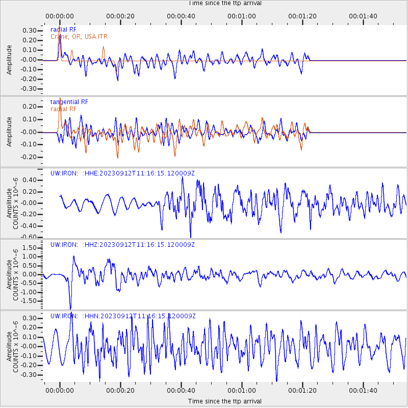
Signal To Noise
| Channel | StoN | STA | LTA |
| UW:IRON: :HHZ:20230912T11:16:15.120009Z | 6.6014323 | 6.7751455E-7 | 1.02631454E-7 |
| UW:IRON: :HHN:20230912T11:16:15.120009Z | 3.5754685 | 1.6404542E-7 | 4.5880817E-8 |
| UW:IRON: :HHE:20230912T11:16:15.120009Z | 1.6006773 | 1.442122E-7 | 9.009449E-8 |
| Arrivals |
| Ps | |
| PpPs | |
| PsPs/PpSs | |


