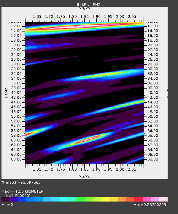
KBL Kabul, Afghanistan - Earthquake Result Viewer
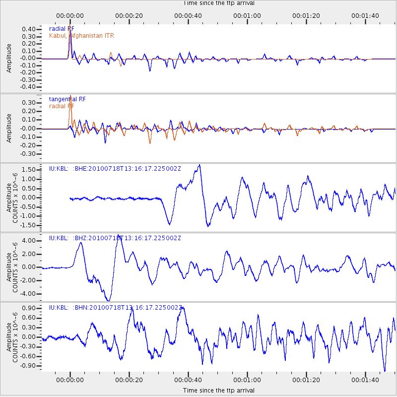
Earthquake location: New Britain Region, P.N.G.
Earthquake latitude/longitude: -6.0/150.4
Earthquake time(UTC): 2010/07/18 (199) 13:04:09 GMT
Earthquake Depth: 28 km
Earthquake Magnitude: 6.3 MB, 7.1 MS, 6.9 MW, 6.8 MW
Earthquake Catalog/Contributor: WHDF/NEIC
Network: IU Global Seismograph Network (GSN - IRIS/USGS)
Station: KBL Kabul, Afghanistan
Lat/Lon: 34.54 N/69.04 E
Elevation: 1920 m
Distance: 86.3 deg
Az: 305.125 deg
Baz: 99.769 deg
Ray Param: 0.044125255
Estimated Moho Depth: 12.0 km
Estimated Crust Vp/Vs: 1.81
Assumed Crust Vp: 6.641 km/s
Estimated Crust Vs: 3.669 km/s
Estimated Crust Poisson's Ratio: 0.28
Radial Match: 93.097565 %
Radial Bump: 400
Transverse Match: 85.50301 %
Transverse Bump: 400
SOD ConfigId: 319893
Insert Time: 2011-01-05 06:33:27.186 +0000
GWidth: 2.5
Max Bumps: 400
Tol: 0.001

Signal To Noise

ChannelStoNSTALTA
IU:KBL: :BHZ:20100718T13:16:17.225002Z37.2273562.1922383E-65.8887835E-8
IU:KBL: :BHN:20100718T13:16:17.225002Z2.2009128.8061974E-84.0011585E-8
IU:KBL: :BHE:20100718T13:16:17.225002Z18.5888547.7355435E-74.161388E-8
Arrivals
Ps1.5 SECOND
PpPs5.0 SECOND
PsPs/PpSs6.5 SECOND