You are here: Home > Network List > XL17 - McGill Dawson-Septimus Induced Seismicity Study () Stations List
> Station MG03 Z > Earthquake Result Viewer
MG03 Z - Earthquake Result Viewer
| Earthquake location: |
Philippine Islands Region |
| Earthquake latitude/longitude: |
19.3/121.2 |
| Earthquake time(UTC): |
2023/09/12 (255) 11:03:18 GMT |
| Earthquake Depth: |
41 km |
| Earthquake Magnitude: |
6.3 Mww |
| Earthquake Catalog/Contributor: |
NEIC PDE/us |
|
| Network: |
XL McGill Dawson-Septimus Induced Seismicity Study () |
| Station: |
MG03 Z |
| Lat/Lon: |
55.91 N/120.44 W |
| Elevation: |
697 m |
|
| Distance: |
88.9 deg |
| Az: |
29.712 deg |
| Baz: |
303.738 deg |
| Ray Param: |
0.042163223 |
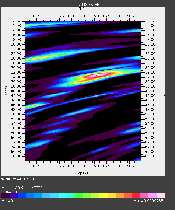
| Estimated Moho Depth: |
33.0 km |
| Estimated Crust Vp/Vs: |
1.90 |
| Assumed Crust Vp: |
6.303 km/s |
| Estimated Crust Vs: |
3.308 km/s |
| Estimated Crust Poisson's Ratio: |
0.31 |
|
| Radial Match: |
89.77709 % |
| Radial Bump: |
398 |
| Transverse Match: |
77.871864 % |
| Transverse Bump: |
400 |
| SOD ConfigId: |
31937991 |
| Insert Time: |
2023-09-26 11:33:53.336 +0000 |
| GWidth: |
2.5 |
| Max Bumps: |
400 |
| Tol: |
0.001 |
|

Signal To Noise
| Channel | StoN | STA | LTA |
| XL:MG03: :HHZ:20230912T11:15:37.820021Z | 20.828272 | 4.262555E-6 | 2.0465237E-7 |
| XL:MG03: :HHN:20230912T11:15:37.820021Z | 3.0570314 | 6.963263E-7 | 2.2777859E-7 |
| XL:MG03: :HHE:20230912T11:15:37.820021Z | 6.8178277 | 1.1321223E-6 | 1.6605323E-7 |
| Arrivals |
| Ps | 4.8 SECOND |
| PpPs | 15 SECOND |
| PsPs/PpSs | 20 SECOND |


