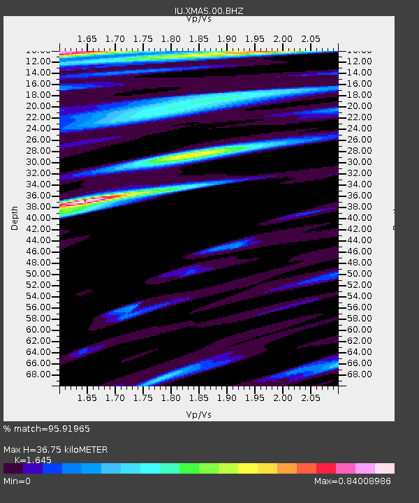
XMAS Kiritimati Island, Republic of Kiribati - Earthquake Result Viewer
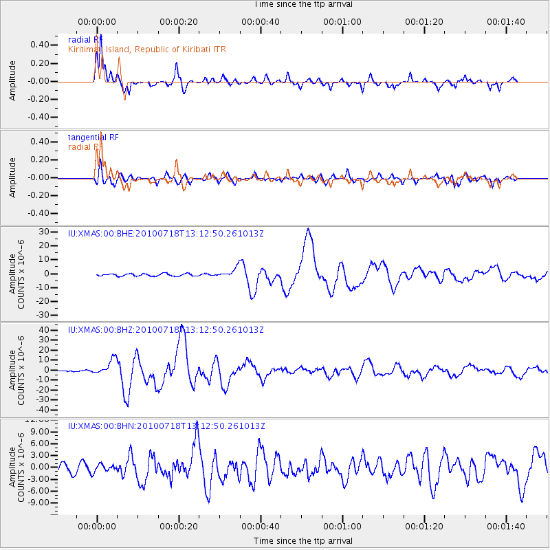
Earthquake location: New Britain Region, P.N.G.
Earthquake latitude/longitude: -6.0/150.4
Earthquake time(UTC): 2010/07/18 (199) 13:04:09 GMT
Earthquake Depth: 28 km
Earthquake Magnitude: 6.3 MB, 7.1 MS, 6.9 MW, 6.8 MW
Earthquake Catalog/Contributor: WHDF/NEIC
Network: IU Global Seismograph Network (GSN - IRIS/USGS)
Station: XMAS Kiritimati Island, Republic of Kiribati
Lat/Lon: 2.04 N/157.45 W
Elevation: 20 m
Distance: 52.7 deg
Az: 82.876 deg
Baz: 260.966 deg
Ray Param: 0.066573486
Estimated Moho Depth: 36.75 km
Estimated Crust Vp/Vs: 1.64
Assumed Crust Vp: 4.802 km/s
Estimated Crust Vs: 2.919 km/s
Estimated Crust Poisson's Ratio: 0.21
Radial Match: 95.91965 %
Radial Bump: 394
Transverse Match: 86.03962 %
Transverse Bump: 400
SOD ConfigId: 319893
Insert Time: 2011-01-05 06:33:44.619 +0000
GWidth: 2.5
Max Bumps: 400
Tol: 0.001

Signal To Noise

ChannelStoNSTALTA
IU:XMAS:00:BHZ:20100718T13:12:50.261013Z14.6844038.418934E-65.733249E-7
IU:XMAS:00:BHN:20100718T13:12:50.261013Z0.980085438.498814E-78.6715033E-7
IU:XMAS:00:BHE:20100718T13:12:50.261013Z4.42373233.7649177E-68.510727E-7
Arrivals
Ps5.1 SECOND
PpPs20 SECOND
PsPs/PpSs25 SECOND