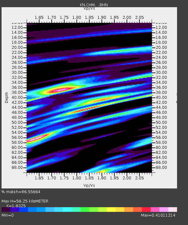
CHM KN.CHM - Earthquake Result Viewer
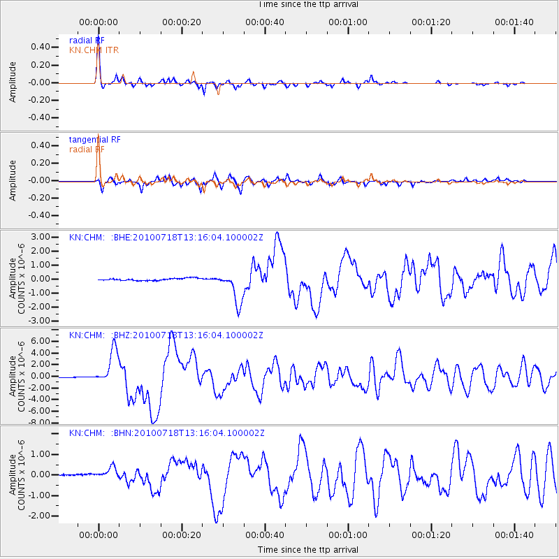
Earthquake location: New Britain Region, P.N.G.
Earthquake latitude/longitude: -6.0/150.4
Earthquake time(UTC): 2010/07/18 (199) 13:04:09 GMT
Earthquake Depth: 28 km
Earthquake Magnitude: 6.3 MB, 7.1 MS, 6.9 MW, 6.8 MW
Earthquake Catalog/Contributor: WHDF/NEIC
Network: KN Kyrgyz Seismic Telemetry Network
Station: CHM KN.CHM
Lat/Lon: 43.00 N/74.75 E
Elevation: 655 m
Distance: 83.7 deg
Az: 314.339 deg
Baz: 104.15 deg
Ray Param: 0.045993667
Estimated Moho Depth: 56.25 km
Estimated Crust Vp/Vs: 1.63
Assumed Crust Vp: 6.306 km/s
Estimated Crust Vs: 3.863 km/s
Estimated Crust Poisson's Ratio: 0.20
Radial Match: 96.55664 %
Radial Bump: 264
Transverse Match: 90.906845 %
Transverse Bump: 400
SOD ConfigId: 319893
Insert Time: 2011-01-05 06:34:16.444 +0000
GWidth: 2.5
Max Bumps: 400
Tol: 0.001

Signal To Noise

ChannelStoNSTALTA
KN:CHM: :BHZ:20100718T13:16:04.100002Z97.455883.1466311E-63.228775E-8
KN:CHM: :BHN:20100718T13:16:04.100002Z2.11041643.7929323E-71.7972435E-7
KN:CHM: :BHE:20100718T13:16:04.100002Z15.3902141.211076E-67.869131E-8
Arrivals
Ps5.8 SECOND
PpPs23 SECOND
PsPs/PpSs29 SECOND