J05D Fort Rock, OR, USA - Earthquake Result Viewer
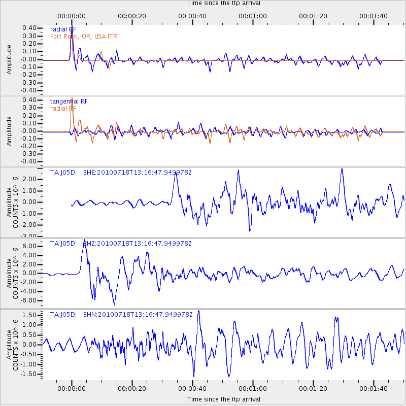
Earthquake location: New Britain Region, P.N.G.
Earthquake latitude/longitude: -6.0/150.4
Earthquake time(UTC): 2010/07/18 (199) 13:04:09 GMT
Earthquake Depth: 28 km
Earthquake Magnitude: 6.3 MB, 7.1 MS, 6.9 MW, 6.8 MW
Earthquake Catalog/Contributor: WHDF/NEIC
Network: TA USArray Transportable Network (new EarthScope stations)
Station: J05D Fort Rock, OR, USA
Lat/Lon: 43.28 N/121.23 W
Elevation: 1541 m
Distance: 92.8 deg
Az: 46.957 deg
Baz: 264.535 deg
Ray Param: 0.04137151
Estimated Moho Depth: 21.0 km
Estimated Crust Vp/Vs: 1.92
Assumed Crust Vp: 6.597 km/s
Estimated Crust Vs: 3.441 km/s
Estimated Crust Poisson's Ratio: 0.31
Radial Match: 94.125595 %
Radial Bump: 400
Transverse Match: 84.48359 %
Transverse Bump: 400
SOD ConfigId: 319893
Insert Time: 2011-01-05 06:36:43.413 +0000
GWidth: 2.5
Max Bumps: 400
Tol: 0.001

Signal To Noise

ChannelStoNSTALTA
TA:J05D: :BHZ:20100718T13:16:47.949978Z25.1336523.271932E-61.3018132E-7
TA:J05D: :BHN:20100718T13:16:47.949978Z1.2863682.604269E-72.0245133E-7
TA:J05D: :BHE:20100718T13:16:47.949978Z6.78543661.0715231E-61.5791512E-7
Arrivals
Ps3.0 SECOND
PpPs9.1 SECOND
PsPs/PpSs12 SECOND