You are here: Home > Network List > US - United States National Seismic Network Stations List
> Station WMOK Wichita Mountains, Oklahoma, USA > Earthquake Result Viewer
WMOK Wichita Mountains, Oklahoma, USA - Earthquake Result Viewer
| Earthquake location: |
Western Brazil |
| Earthquake latitude/longitude: |
-8.1/-71.6 |
| Earthquake time(UTC): |
2019/01/05 (005) 19:25:38 GMT |
| Earthquake Depth: |
575 km |
| Earthquake Magnitude: |
6.8 Mww |
| Earthquake Catalog/Contributor: |
NEIC PDE/us |
|
| Network: |
US United States National Seismic Network |
| Station: |
WMOK Wichita Mountains, Oklahoma, USA |
| Lat/Lon: |
34.74 N/98.78 W |
| Elevation: |
486 m |
|
| Distance: |
49.8 deg |
| Az: |
330.468 deg |
| Baz: |
143.661 deg |
| Ray Param: |
0.06579064 |
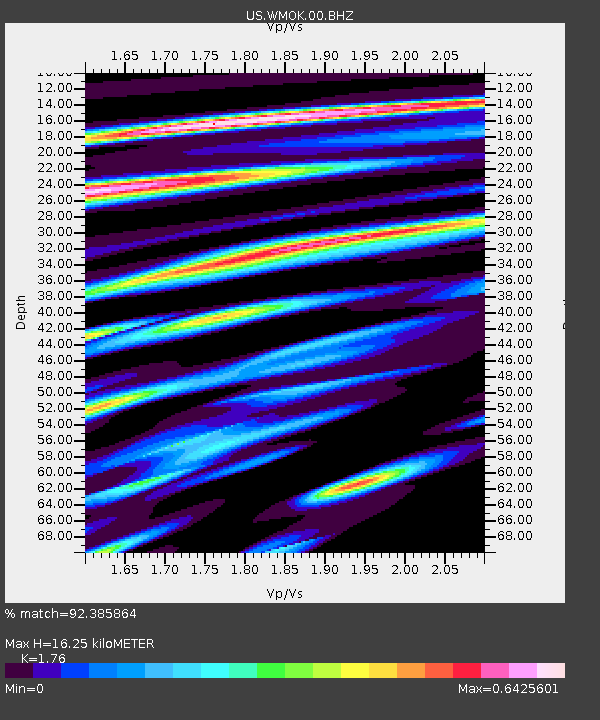
| Estimated Moho Depth: |
16.25 km |
| Estimated Crust Vp/Vs: |
1.76 |
| Assumed Crust Vp: |
6.315 km/s |
| Estimated Crust Vs: |
3.588 km/s |
| Estimated Crust Poisson's Ratio: |
0.26 |
|
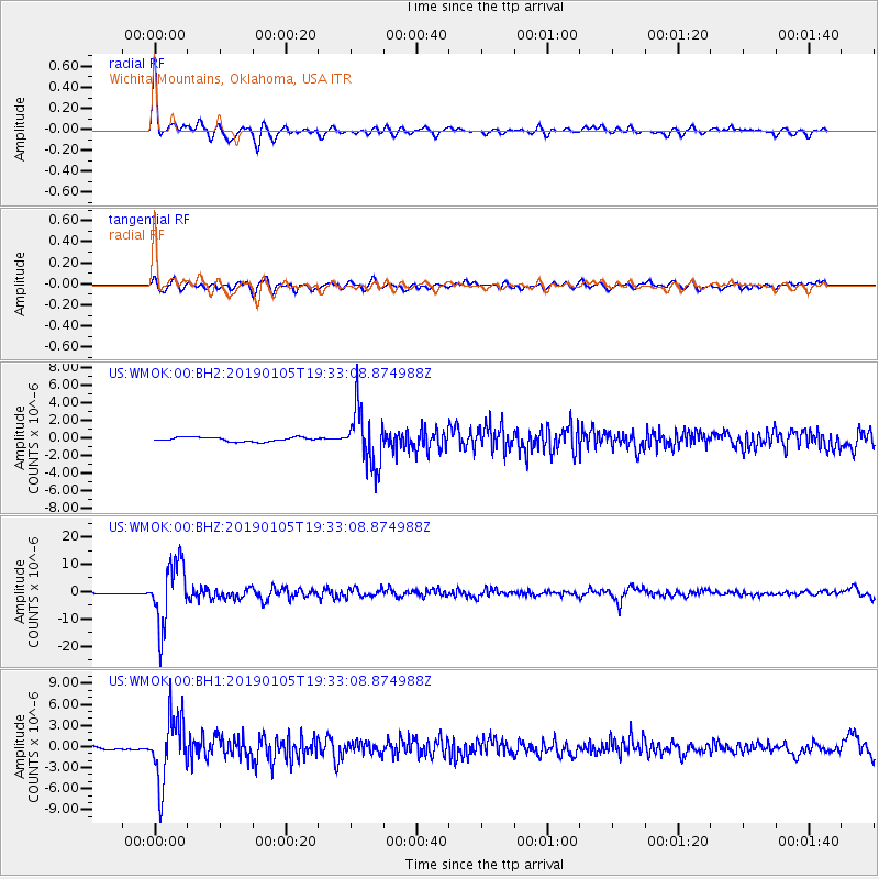
| Radial Match: |
92.385864 % |
| Radial Bump: |
400 |
| Transverse Match: |
79.6335 % |
| Transverse Bump: |
400 |
| SOD ConfigId: |
3201911 |
| Insert Time: |
2019-01-19 19:42:03.440 +0000 |
| GWidth: |
2.5 |
| Max Bumps: |
400 |
| Tol: |
0.001 |
|
Signal To Noise
| Channel | StoN | STA | LTA |
| US:WMOK:00:BHZ:20190105T19:33:08.874988Z | 50.11785 | 1.14102495E-5 | 2.2766837E-7 |
| US:WMOK:00:BH1:20190105T19:33:08.874988Z | 23.900003 | 4.6363903E-6 | 1.9399121E-7 |
| US:WMOK:00:BH2:20190105T19:33:08.874988Z | 13.301325 | 3.2372352E-6 | 2.433769E-7 |
| Arrivals |
| Ps | 2.1 SECOND |
| PpPs | 6.7 SECOND |
| PsPs/PpSs | 8.8 SECOND |


