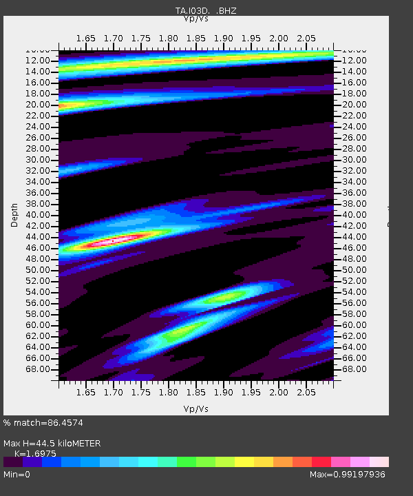
I03D Drain, OR, USA - Earthquake Result Viewer

Earthquake location: New Britain Region, P.N.G.
Earthquake latitude/longitude: -6.0/150.4
Earthquake time(UTC): 2010/07/18 (199) 13:04:09 GMT
Earthquake Depth: 28 km
Earthquake Magnitude: 6.3 MB, 7.1 MS, 6.9 MW, 6.8 MW
Earthquake Catalog/Contributor: WHDF/NEIC
Network: TA USArray Transportable Network (new EarthScope stations)
Station: I03D Drain, OR, USA
Lat/Lon: 43.70 N/123.35 W
Elevation: 140 m
Distance: 91.3 deg
Az: 46.381 deg
Baz: 263.106 deg
Ray Param: 0.04160527
Estimated Moho Depth: 44.5 km
Estimated Crust Vp/Vs: 1.70
Assumed Crust Vp: 6.522 km/s
Estimated Crust Vs: 3.842 km/s
Estimated Crust Poisson's Ratio: 0.23
Radial Match: 86.4574 %
Radial Bump: 400
Transverse Match: 70.99304 %
Transverse Bump: 400
SOD ConfigId: 319893
Insert Time: 2011-01-05 06:37:10.180 +0000
GWidth: 2.5
Max Bumps: 400
Tol: 0.001

Signal To Noise

ChannelStoNSTALTA
TA:I03D: :BHZ:20100718T13:16:41.100002Z16.4030723.173597E-61.9347577E-7
TA:I03D: :BHN:20100718T13:16:41.100002Z2.7723193.7918466E-71.3677526E-7
TA:I03D: :BHE:20100718T13:16:41.100002Z5.536691.0949129E-61.9775587E-7
Arrivals
Ps4.9 SECOND
PpPs18 SECOND
PsPs/PpSs23 SECOND