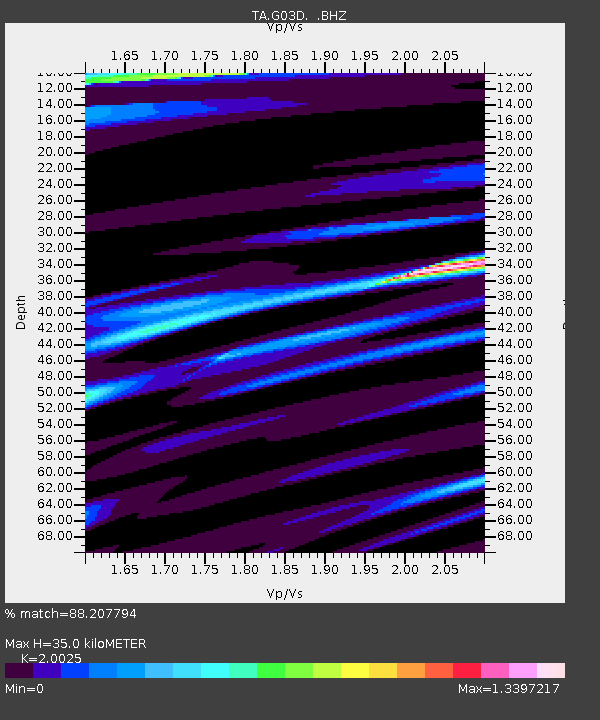
G03D McMinnville, OR, USA - Earthquake Result Viewer
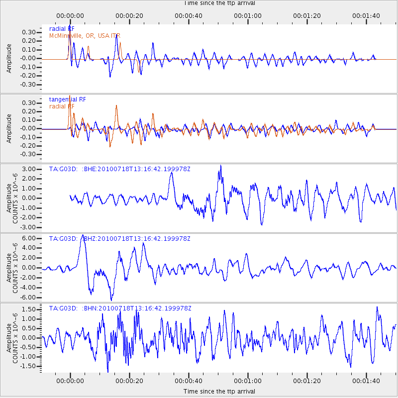
Earthquake location: New Britain Region, P.N.G.
Earthquake latitude/longitude: -6.0/150.4
Earthquake time(UTC): 2010/07/18 (199) 13:04:09 GMT
Earthquake Depth: 28 km
Earthquake Magnitude: 6.3 MB, 7.1 MS, 6.9 MW, 6.8 MW
Earthquake Catalog/Contributor: WHDF/NEIC
Network: TA USArray Transportable Network (new EarthScope stations)
Station: G03D McMinnville, OR, USA
Lat/Lon: 45.21 N/123.26 W
Elevation: 222 m
Distance: 91.6 deg
Az: 44.884 deg
Baz: 263.204 deg
Ray Param: 0.041580133
Estimated Moho Depth: 35.0 km
Estimated Crust Vp/Vs: 2.00
Assumed Crust Vp: 6.566 km/s
Estimated Crust Vs: 3.279 km/s
Estimated Crust Poisson's Ratio: 0.33
Radial Match: 88.207794 %
Radial Bump: 400
Transverse Match: 76.70106 %
Transverse Bump: 400
SOD ConfigId: 319893
Insert Time: 2011-01-05 06:37:10.243 +0000
GWidth: 2.5
Max Bumps: 400
Tol: 0.001

Signal To Noise

ChannelStoNSTALTA
TA:G03D: :BHZ:20100718T13:16:42.199978Z10.4877043.3376375E-63.182429E-7
TA:G03D: :BHN:20100718T13:16:42.199978Z1.15689063.1392506E-72.713524E-7
TA:G03D: :BHE:20100718T13:16:42.199978Z3.63805171.2030521E-63.306858E-7
Arrivals
Ps5.4 SECOND
PpPs16 SECOND
PsPs/PpSs21 SECOND