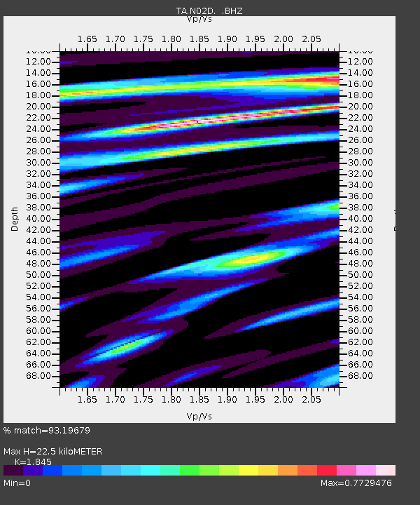
N02D Trinity Center, CA, USA - Earthquake Result Viewer
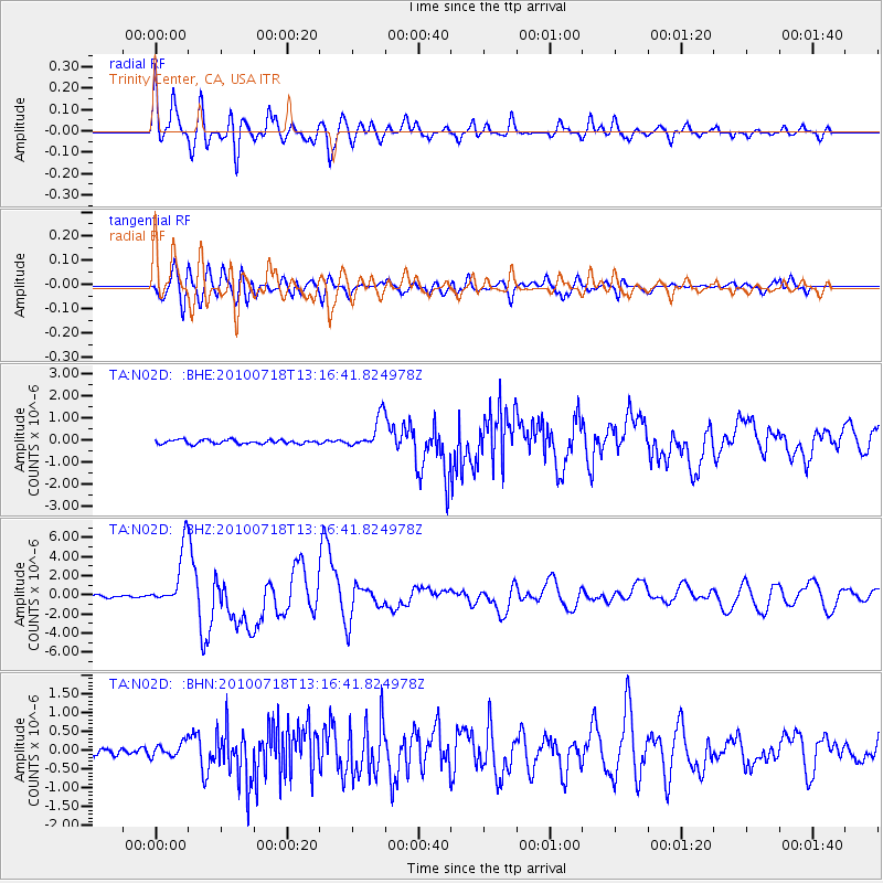
Earthquake location: New Britain Region, P.N.G.
Earthquake latitude/longitude: -6.0/150.4
Earthquake time(UTC): 2010/07/18 (199) 13:04:09 GMT
Earthquake Depth: 28 km
Earthquake Magnitude: 6.3 MB, 7.1 MS, 6.9 MW, 6.8 MW
Earthquake Catalog/Contributor: WHDF/NEIC
Network: TA USArray Transportable Network (new EarthScope stations)
Station: N02D Trinity Center, CA, USA
Lat/Lon: 40.97 N/122.71 W
Elevation: 937 m
Distance: 91.5 deg
Az: 49.14 deg
Baz: 263.47 deg
Ray Param: 0.041592956
Estimated Moho Depth: 22.5 km
Estimated Crust Vp/Vs: 1.85
Assumed Crust Vp: 6.566 km/s
Estimated Crust Vs: 3.559 km/s
Estimated Crust Poisson's Ratio: 0.29
Radial Match: 93.19679 %
Radial Bump: 400
Transverse Match: 87.26775 %
Transverse Bump: 400
SOD ConfigId: 319893
Insert Time: 2011-01-05 06:37:22.738 +0000
GWidth: 2.5
Max Bumps: 400
Tol: 0.001

Signal To Noise

ChannelStoNSTALTA
TA:N02D: :BHZ:20100718T13:16:41.824978Z21.9289862.9971093E-61.3667342E-7
TA:N02D: :BHN:20100718T13:16:41.824978Z1.8620151.8669515E-71.00265105E-7
TA:N02D: :BHE:20100718T13:16:41.824978Z8.017377.245426E-79.037161E-8
Arrivals
Ps3.0 SECOND
PpPs9.5 SECOND
PsPs/PpSs13 SECOND