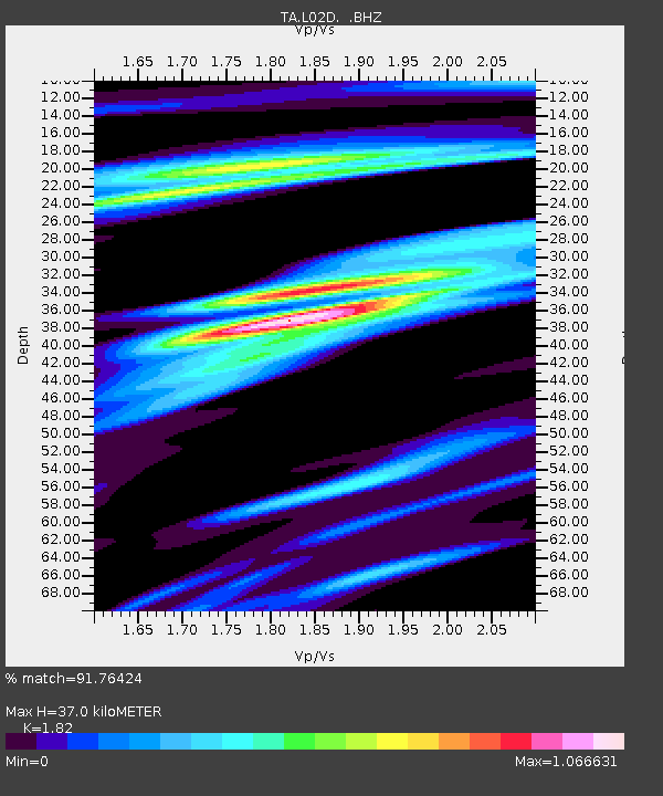
L02D Cave Junction, OR, USA - Earthquake Result Viewer
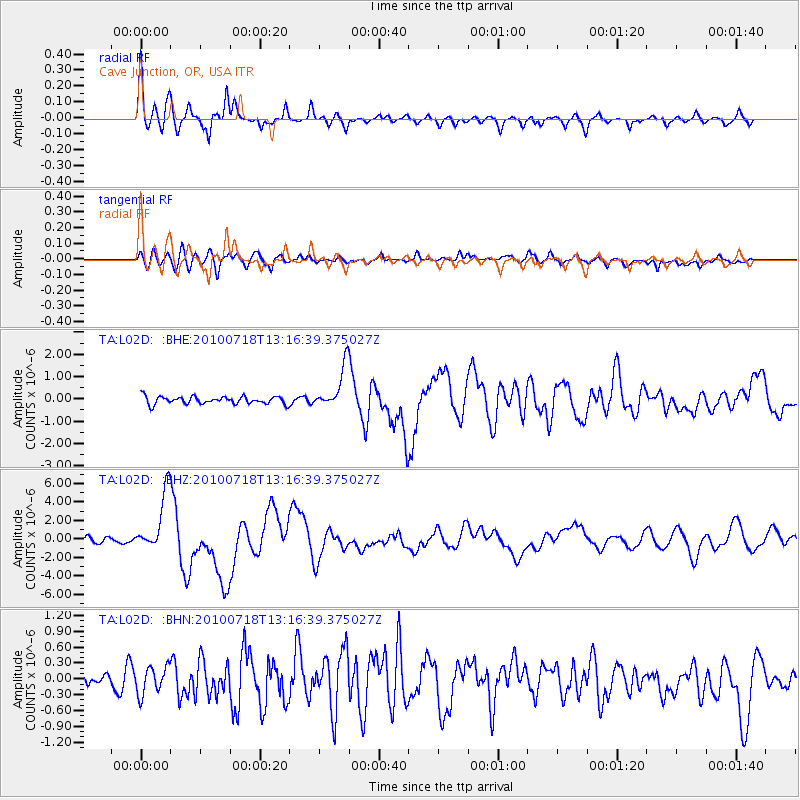
Earthquake location: New Britain Region, P.N.G.
Earthquake latitude/longitude: -6.0/150.4
Earthquake time(UTC): 2010/07/18 (199) 13:04:09 GMT
Earthquake Depth: 28 km
Earthquake Magnitude: 6.3 MB, 7.1 MS, 6.9 MW, 6.8 MW
Earthquake Catalog/Contributor: WHDF/NEIC
Network: TA USArray Transportable Network (new EarthScope stations)
Station: L02D Cave Junction, OR, USA
Lat/Lon: 42.16 N/123.60 W
Elevation: 458 m
Distance: 91.0 deg
Az: 47.885 deg
Baz: 262.903 deg
Ray Param: 0.041631866
Estimated Moho Depth: 37.0 km
Estimated Crust Vp/Vs: 1.82
Assumed Crust Vp: 6.522 km/s
Estimated Crust Vs: 3.583 km/s
Estimated Crust Poisson's Ratio: 0.28
Radial Match: 91.76424 %
Radial Bump: 400
Transverse Match: 70.225204 %
Transverse Bump: 400
SOD ConfigId: 319893
Insert Time: 2011-01-05 06:37:23.185 +0000
GWidth: 2.5
Max Bumps: 400
Tol: 0.001

Signal To Noise

ChannelStoNSTALTA
TA:L02D: :BHZ:20100718T13:16:39.375027Z13.3016223.2051632E-62.4096033E-7
TA:L02D: :BHN:20100718T13:16:39.375027Z1.94179692.598901E-71.3384E-7
TA:L02D: :BHE:20100718T13:16:39.375027Z5.65319359.457902E-71.6730193E-7
Arrivals
Ps4.7 SECOND
PpPs16 SECOND
PsPs/PpSs20 SECOND