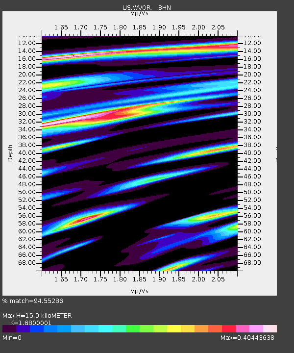
WVOR Wild Horse Valley, Oregon, USA - Earthquake Result Viewer
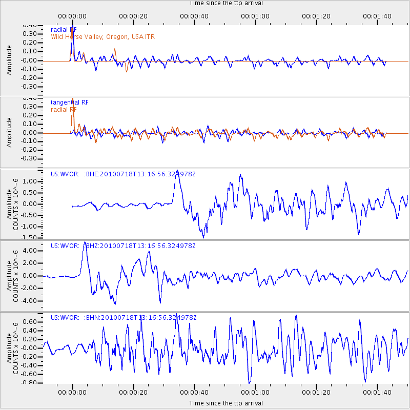
Earthquake location: New Britain Region, P.N.G.
Earthquake latitude/longitude: -6.0/150.4
Earthquake time(UTC): 2010/07/18 (199) 13:04:09 GMT
Earthquake Depth: 28 km
Earthquake Magnitude: 6.3 MB, 7.1 MS, 6.9 MW, 6.8 MW
Earthquake Catalog/Contributor: WHDF/NEIC
Network: US United States National Seismic Network
Station: WVOR Wild Horse Valley, Oregon, USA
Lat/Lon: 42.43 N/118.64 W
Elevation: 1344 m
Distance: 94.7 deg
Az: 47.96 deg
Baz: 266.231 deg
Ray Param: 0.04097488
Estimated Moho Depth: 15.0 km
Estimated Crust Vp/Vs: 1.68
Assumed Crust Vp: 6.279 km/s
Estimated Crust Vs: 3.737 km/s
Estimated Crust Poisson's Ratio: 0.23
Radial Match: 94.55286 %
Radial Bump: 337
Transverse Match: 88.53601 %
Transverse Bump: 400
SOD ConfigId: 319893
Insert Time: 2011-01-05 06:38:11.003 +0000
GWidth: 2.5
Max Bumps: 400
Tol: 0.001

Signal To Noise

ChannelStoNSTALTA
US:WVOR: :BHZ:20100718T13:16:56.324978Z27.912892.5695037E-69.205438E-8
US:WVOR: :BHN:20100718T13:16:56.324978Z0.988281138.18389E-88.280933E-8
US:WVOR: :BHE:20100718T13:16:56.324978Z8.9771276.8703747E-77.6532004E-8
Arrivals
Ps1.7 SECOND
PpPs6.3 SECOND
PsPs/PpSs7.9 SECOND