MSO Missoula, Montana, USA - Earthquake Result Viewer
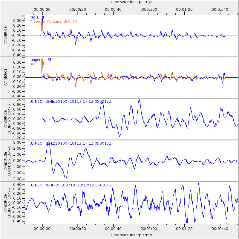
Earthquake location: New Britain Region, P.N.G.
Earthquake latitude/longitude: -6.0/150.4
Earthquake time(UTC): 2010/07/18 (199) 13:04:09 GMT
Earthquake Depth: 28 km
Earthquake Magnitude: 6.3 MB, 7.1 MS, 6.9 MW, 6.8 MW
Earthquake Catalog/Contributor: WHDF/NEIC
Network: US United States National Seismic Network
Station: MSO Missoula, Montana, USA
Lat/Lon: 46.83 N/113.94 W
Elevation: 1264 m
Distance: 98.2 deg
Az: 43.654 deg
Baz: 270.004 deg
Ray Param: 0.039974015
Estimated Moho Depth: 35.25 km
Estimated Crust Vp/Vs: 1.74
Assumed Crust Vp: 6.353 km/s
Estimated Crust Vs: 3.662 km/s
Estimated Crust Poisson's Ratio: 0.25
Radial Match: 93.31684 %
Radial Bump: 379
Transverse Match: 73.030975 %
Transverse Bump: 400
SOD ConfigId: 319893
Insert Time: 2011-01-05 06:38:24.124 +0000
GWidth: 2.5
Max Bumps: 400
Tol: 0.001

Signal To Noise

ChannelStoNSTALTA
US:MSO: :BHZ:20100718T13:17:12.050015Z14.5754411.7652453E-61.2111093E-7
US:MSO: :BHN:20100718T13:17:12.050015Z0.739787047.619354E-81.0299388E-7
US:MSO: :BHE:20100718T13:17:12.050015Z6.5528745.907993E-79.015881E-8
Arrivals
Ps4.2 SECOND
PpPs15 SECOND
PsPs/PpSs19 SECOND