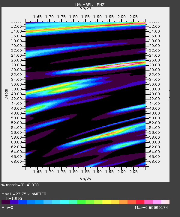
MRBL Marblemount, WA, USA - Earthquake Result Viewer
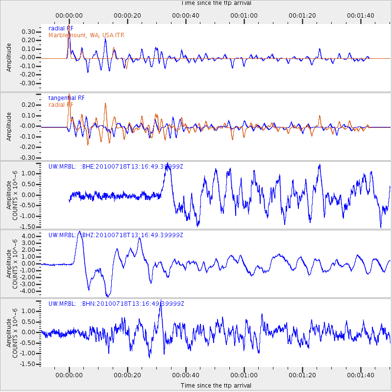
Earthquake location: New Britain Region, P.N.G.
Earthquake latitude/longitude: -6.0/150.4
Earthquake time(UTC): 2010/07/18 (199) 13:04:09 GMT
Earthquake Depth: 28 km
Earthquake Magnitude: 6.3 MB, 7.1 MS, 6.9 MW, 6.8 MW
Earthquake Catalog/Contributor: WHDF/NEIC
Network: UW Pacific Northwest Regional Seismic Network
Station: MRBL Marblemount, WA, USA
Lat/Lon: 48.52 N/121.48 W
Elevation: 75 m
Distance: 93.2 deg
Az: 41.722 deg
Baz: 264.63 deg
Ray Param: 0.041308105
Estimated Moho Depth: 27.75 km
Estimated Crust Vp/Vs: 2.00
Assumed Crust Vp: 6.566 km/s
Estimated Crust Vs: 3.291 km/s
Estimated Crust Poisson's Ratio: 0.33
Radial Match: 91.41938 %
Radial Bump: 400
Transverse Match: 82.49246 %
Transverse Bump: 400
SOD ConfigId: 319893
Insert Time: 2011-01-05 06:39:09.073 +0000
GWidth: 2.5
Max Bumps: 400
Tol: 0.001

Signal To Noise

ChannelStoNSTALTA
UW:MRBL: :BHZ:20100718T13:16:49.39999Z37.8409732.7008632E-67.1374046E-8
UW:MRBL: :BHN:20100718T13:16:49.39999Z1.10172391.0101984E-79.169252E-8
UW:MRBL: :BHE:20100718T13:16:49.39999Z8.59721858.184183E-79.5195716E-8
Arrivals
Ps4.3 SECOND
PpPs12 SECOND
PsPs/PpSs17 SECOND