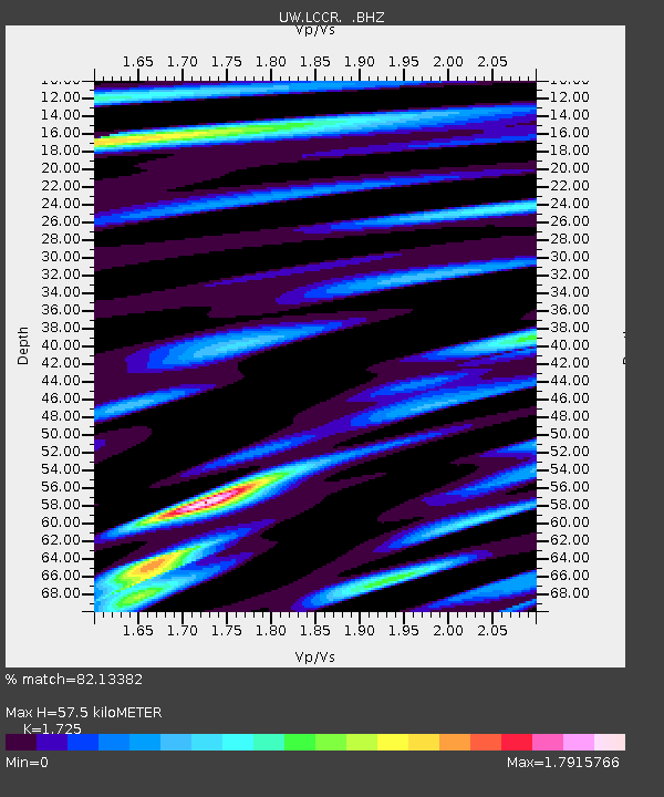
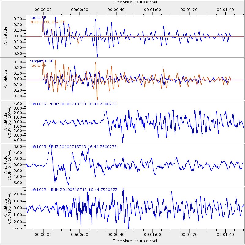
LCCR Mulino, OR, USA - Earthquake Result Viewer

Earthquake location: New Britain Region, P.N.G.
Earthquake latitude/longitude: -6.0/150.4
Earthquake time(UTC): 2010/07/18 (199) 13:04:09 GMT
Earthquake Depth: 28 km
Earthquake Magnitude: 6.3 MB, 7.1 MS, 6.9 MW, 6.8 MW
Earthquake Catalog/Contributor: WHDF/NEIC
Network: UW Pacific Northwest Regional Seismic Network
Station: LCCR Mulino, OR, USA
Lat/Lon: 45.21 N/122.48 W
Elevation: 273 m
Distance: 92.1 deg
Az: 44.953 deg
Baz: 263.757 deg
Ray Param: 0.041496594
Estimated Moho Depth: 57.5 km
Estimated Crust Vp/Vs: 1.73
Assumed Crust Vp: 6.566 km/s
Estimated Crust Vs: 3.806 km/s
Estimated Crust Poisson's Ratio: 0.25
Radial Match: 82.13382 %
Radial Bump: 400
Transverse Match: 65.55881 %
Transverse Bump: 400
SOD ConfigId: 319893
Insert Time: 2011-01-05 06:39:23.139 +0000
GWidth: 2.5
Max Bumps: 400
Tol: 0.001

Signal To Noise

ChannelStoNSTALTA
UW:LCCR: :BHZ:20100718T13:16:44.750027Z18.5908243.496957E-61.8810124E-7
UW:LCCR: :BHN:20100718T13:16:44.750027Z0.643408832.5266607E-73.926991E-7
UW:LCCR: :BHE:20100718T13:16:44.750027Z3.47042011.1444107E-63.2976143E-7
Arrivals
Ps6.5 SECOND
PpPs23 SECOND
PsPs/PpSs30 SECOND