You are here: Home > Network List > UU - University of Utah Regional Network Stations List
> Station LIUT Lila Canyon, UT, USA > Earthquake Result Viewer
LIUT Lila Canyon, UT, USA - Earthquake Result Viewer
| Earthquake location: |
Western Brazil |
| Earthquake latitude/longitude: |
-8.1/-71.6 |
| Earthquake time(UTC): |
2019/01/05 (005) 19:25:38 GMT |
| Earthquake Depth: |
575 km |
| Earthquake Magnitude: |
6.8 Mww |
| Earthquake Catalog/Contributor: |
NEIC PDE/us |
|
| Network: |
UU University of Utah Regional Network |
| Station: |
LIUT Lila Canyon, UT, USA |
| Lat/Lon: |
39.42 N/110.33 W |
| Elevation: |
2178 m |
|
| Distance: |
59.4 deg |
| Az: |
325.718 deg |
| Baz: |
133.947 deg |
| Ray Param: |
0.059902705 |
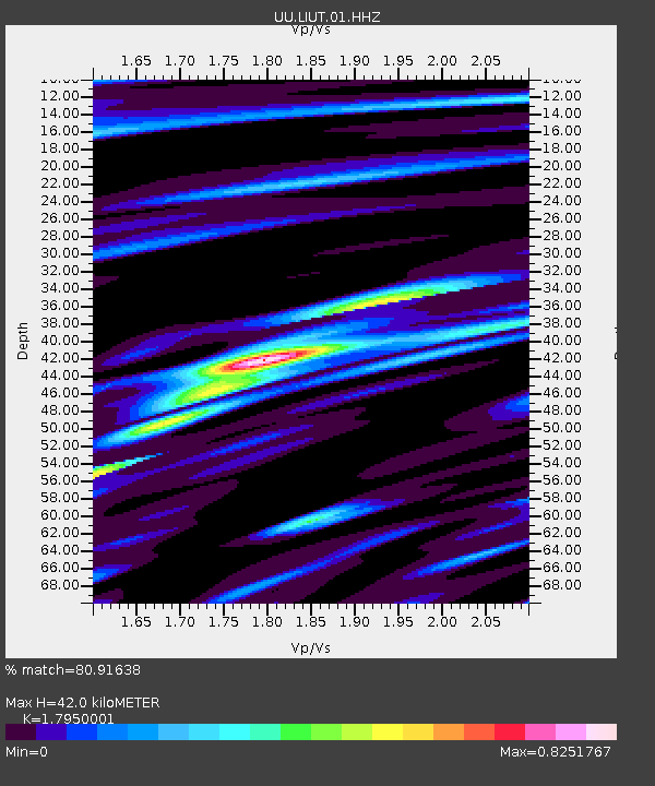
| Estimated Moho Depth: |
42.0 km |
| Estimated Crust Vp/Vs: |
1.80 |
| Assumed Crust Vp: |
6.207 km/s |
| Estimated Crust Vs: |
3.458 km/s |
| Estimated Crust Poisson's Ratio: |
0.27 |
|
| Radial Match: |
80.91638 % |
| Radial Bump: |
400 |
| Transverse Match: |
65.938896 % |
| Transverse Bump: |
400 |
| SOD ConfigId: |
3201911 |
| Insert Time: |
2019-01-19 19:42:39.762 +0000 |
| GWidth: |
2.5 |
| Max Bumps: |
400 |
| Tol: |
0.001 |
|

Signal To Noise
| Channel | StoN | STA | LTA |
| UU:LIUT:01:HHZ:20190105T19:34:15.72002Z | 17.69929 | 2.4384164E-7 | 1.37769165E-8 |
| UU:LIUT:01:HHN:20190105T19:34:15.72002Z | 9.9536 | 8.3118486E-8 | 8.350596E-9 |
| UU:LIUT:01:HHE:20190105T19:34:15.72002Z | 3.6247935 | 6.984003E-8 | 1.9267311E-8 |
| Arrivals |
| Ps | 5.6 SECOND |
| PpPs | 18 SECOND |
| PsPs/PpSs | 24 SECOND |


