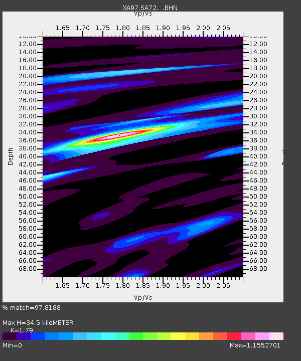
SA72 XA.SA72 - Earthquake Result Viewer
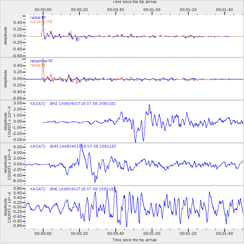
Earthquake location: Southern Sumatra, Indonesia
Earthquake latitude/longitude: -0.5/99.3
Earthquake time(UTC): 1998/04/01 (091) 17:56:23 GMT
Earthquake Depth: 56 km
Earthquake Magnitude: 6.2 MB, 6.9 MS, 7.0 UNKNOWN, 6.6 ME
Earthquake Catalog/Contributor: WHDF/NEIC
Network: XA Anatomy of an Archean Craton, South Africa
Station: SA72 XA.SA72
Lat/Lon: 20.14 S/28.61 E
Elevation: 1337 m
Distance: 71.7 deg
Az: 249.052 deg
Baz: 83.676 deg
Ray Param: 0.054059148
Estimated Moho Depth: 34.5 km
Estimated Crust Vp/Vs: 1.79
Assumed Crust Vp: 6.459 km/s
Estimated Crust Vs: 3.609 km/s
Estimated Crust Poisson's Ratio: 0.27
Radial Match: 97.8188 %
Radial Bump: 233
Transverse Match: 88.36553 %
Transverse Bump: 400
SOD ConfigId: 4480
Insert Time: 2010-02-26 18:30:15.204 +0000
GWidth: 2.5
Max Bumps: 400
Tol: 0.001

Signal To Noise

ChannelStoNSTALTA
XA:SA72: :BHN:19980401T18:07:08.268018Z1.82709283.2810345E-71.795768E-7
XA:SA72: :BHE:19980401T18:07:08.268018Z0.65925428.6190425E-81.307393E-7
XA:SA72: :BHZ:19980401T18:07:08.268018Z1.89014531.4945017E-77.906809E-8
Arrivals
Ps4.4 SECOND
PpPs14 SECOND
PsPs/PpSs19 SECOND