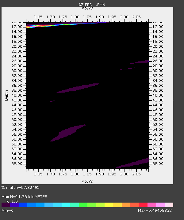
FRD AZ.FRD - Earthquake Result Viewer
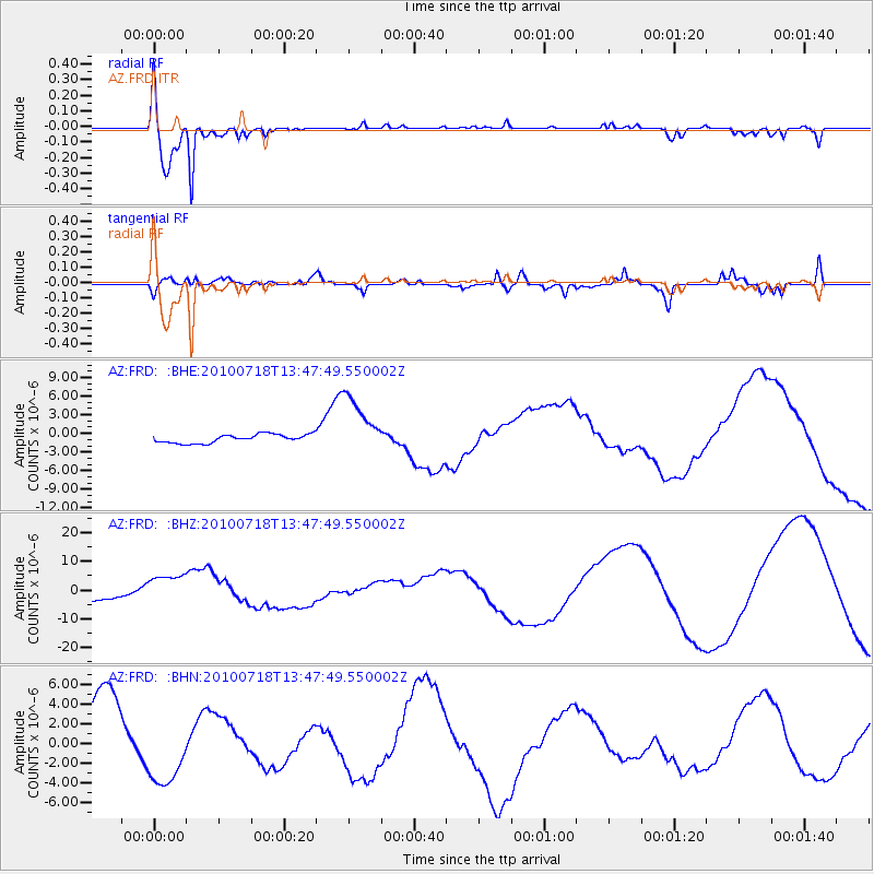
Earthquake location: New Britain Region, P.N.G.
Earthquake latitude/longitude: -5.9/150.6
Earthquake time(UTC): 2010/07/18 (199) 13:34:59 GMT
Earthquake Depth: 35 km
Earthquake Magnitude: 6.1 MB, 7.3 MS, 7.3 MW, 7.3 MW
Earthquake Catalog/Contributor: WHDF/NEIC
Network: AZ ANZA Regional Network
Station: FRD AZ.FRD
Lat/Lon: 33.49 N/116.60 W
Elevation: 1164 m
Distance: 95.6 deg
Az: 56.992 deg
Baz: 266.601 deg
Ray Param: 0.040730942
Estimated Moho Depth: 11.75 km
Estimated Crust Vp/Vs: 1.60
Assumed Crust Vp: 6.264 km/s
Estimated Crust Vs: 3.915 km/s
Estimated Crust Poisson's Ratio: 0.18
Radial Match: 97.32495 %
Radial Bump: 301
Transverse Match: 56.683456 %
Transverse Bump: 400
SOD ConfigId: 319893
Insert Time: 2011-01-05 06:42:45.544 +0000
GWidth: 2.5
Max Bumps: 400
Tol: 0.001

Signal To Noise

ChannelStoNSTALTA
AZ:FRD: :BHZ:20100718T13:47:49.550002Z2.63994966.0239445E-62.2818408E-6
AZ:FRD: :BHN:20100718T13:47:49.550002Z0.937193753.6839754E-63.930858E-6
AZ:FRD: :BHE:20100718T13:47:49.550002Z7.00173574.817524E-66.8804707E-7
Arrivals
Ps1.1 SECOND
PpPs4.8 SECOND
PsPs/PpSs5.9 SECOND