You are here: Home > Network List > XA97 - Anatomy of an Archean Craton, South Africa Stations List
> Station SA72 XA.SA72 > Earthquake Result Viewer
SA72 XA.SA72 - Earthquake Result Viewer
| Earthquake location: |
South Sandwich Islands Region |
| Earthquake latitude/longitude: |
-59.7/-29.2 |
| Earthquake time(UTC): |
1997/10/05 (278) 18:04:30 GMT |
| Earthquake Depth: |
274 km |
| Earthquake Magnitude: |
6.0 MB, 6.3 UNKNOWN, 6.3 MW |
| Earthquake Catalog/Contributor: |
WHDF/NEIC |
|
| Network: |
XA Anatomy of an Archean Craton, South Africa |
| Station: |
SA72 XA.SA72 |
| Lat/Lon: |
20.14 S/28.61 E |
| Elevation: |
1337 m |
|
| Distance: |
56.7 deg |
| Az: |
72.009 deg |
| Baz: |
210.842 deg |
| Ray Param: |
0.06300269 |
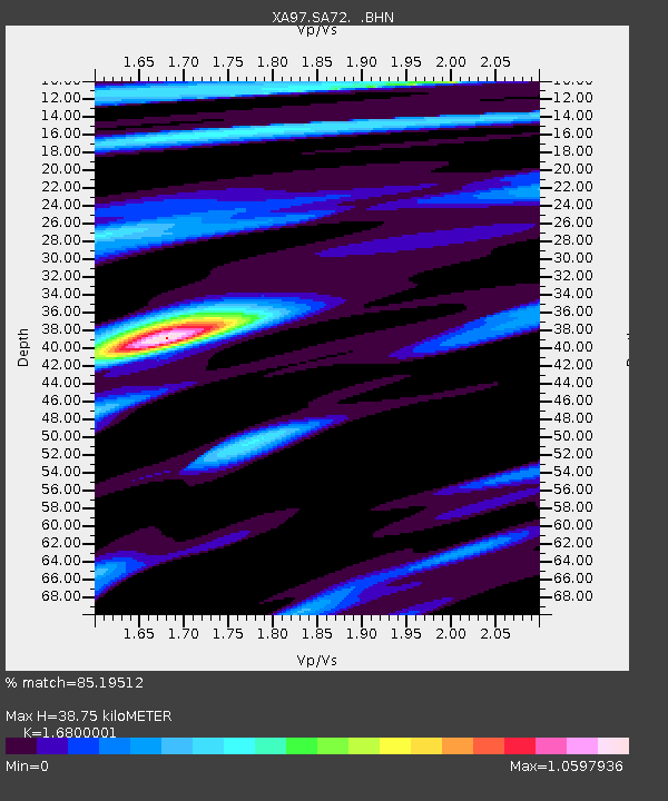
| Estimated Moho Depth: |
38.75 km |
| Estimated Crust Vp/Vs: |
1.68 |
| Assumed Crust Vp: |
6.459 km/s |
| Estimated Crust Vs: |
3.845 km/s |
| Estimated Crust Poisson's Ratio: |
0.23 |
|
| Radial Match: |
85.19512 % |
| Radial Bump: |
400 |
| Transverse Match: |
52.307686 % |
| Transverse Bump: |
400 |
| SOD ConfigId: |
6273 |
| Insert Time: |
2010-02-26 18:30:16.855 +0000 |
| GWidth: |
2.5 |
| Max Bumps: |
400 |
| Tol: |
0.001 |
|

Signal To Noise
| Channel | StoN | STA | LTA |
| XA:SA72: :BHN:19971005T18:13:14.721008Z | 8.155805 | 1.7283461E-6 | 2.1191606E-7 |
| XA:SA72: :BHE:19971005T18:13:14.721008Z | 2.6361587 | 6.707812E-7 | 2.5445405E-7 |
| XA:SA72: :BHZ:19971005T18:13:14.721008Z | 9.896472 | 3.54655E-6 | 3.583651E-7 |
| Arrivals |
| Ps | 4.3 SECOND |
| PpPs | 15 SECOND |
| PsPs/PpSs | 20 SECOND |


