You are here: Home > Network List > CI - Caltech Regional Seismic Network Stations List
> Station GSC Goldstone, Goldstone Lake, CA, USA > Earthquake Result Viewer
GSC Goldstone, Goldstone Lake, CA, USA - Earthquake Result Viewer
| Earthquake location: |
New Britain Region, P.N.G. |
| Earthquake latitude/longitude: |
-5.9/150.6 |
| Earthquake time(UTC): |
2010/07/18 (199) 13:34:59 GMT |
| Earthquake Depth: |
35 km |
| Earthquake Magnitude: |
6.1 MB, 7.3 MS, 7.3 MW, 7.3 MW |
| Earthquake Catalog/Contributor: |
WHDF/NEIC |
|
| Network: |
CI Caltech Regional Seismic Network |
| Station: |
GSC Goldstone, Goldstone Lake, CA, USA |
| Lat/Lon: |
35.30 N/116.81 W |
| Elevation: |
1000 m |
|
| Distance: |
95.5 deg |
| Az: |
55.174 deg |
| Baz: |
266.662 deg |
| Ray Param: |
0.040747426 |
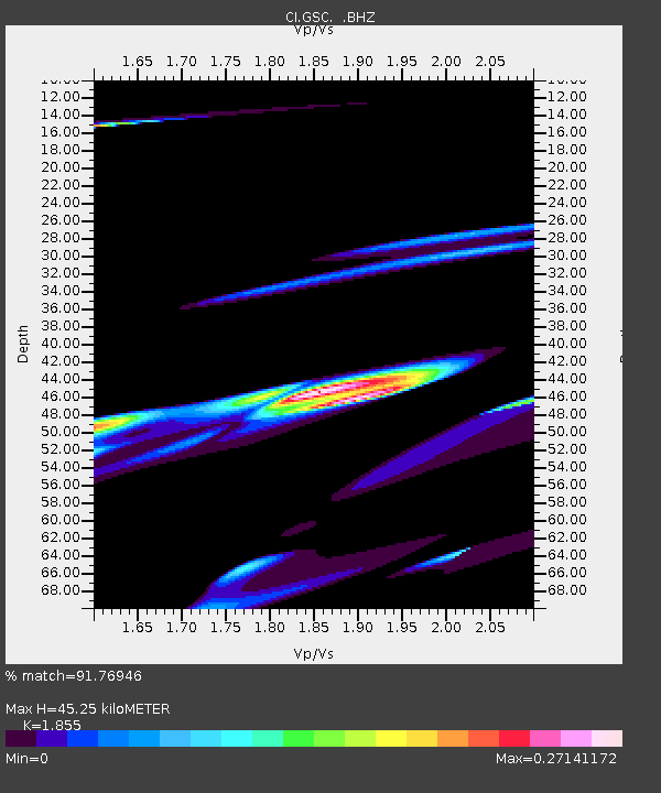
| Estimated Moho Depth: |
45.25 km |
| Estimated Crust Vp/Vs: |
1.86 |
| Assumed Crust Vp: |
6.276 km/s |
| Estimated Crust Vs: |
3.383 km/s |
| Estimated Crust Poisson's Ratio: |
0.30 |
|
| Radial Match: |
91.76946 % |
| Radial Bump: |
400 |
| Transverse Match: |
62.792717 % |
| Transverse Bump: |
400 |
| SOD ConfigId: |
319893 |
| Insert Time: |
2011-01-05 06:44:53.002 +0000 |
| GWidth: |
2.5 |
| Max Bumps: |
400 |
| Tol: |
0.001 |
|
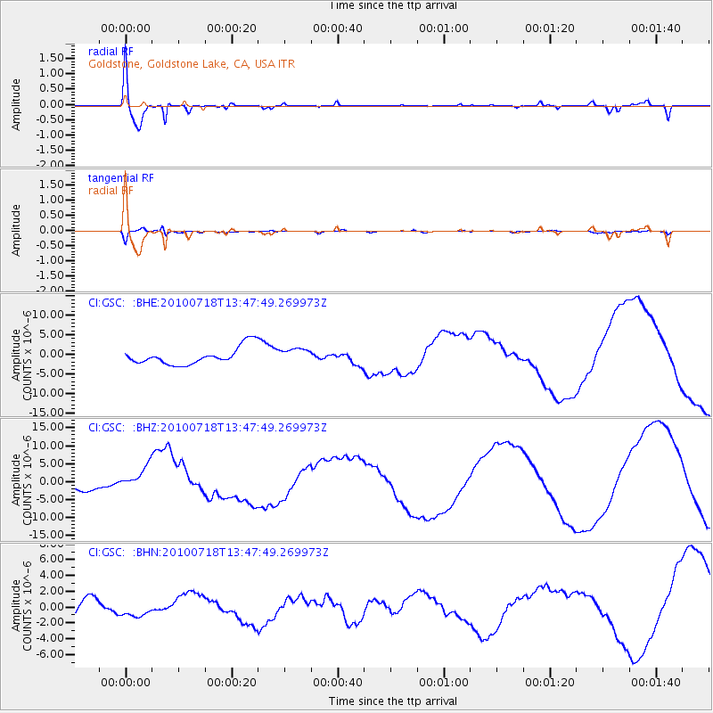
Signal To Noise
| Channel | StoN | STA | LTA |
| CI:GSC: :BHZ:20100718T13:47:49.269973Z | 1.4677905 | 3.8227195E-6 | 2.6044042E-6 |
| CI:GSC: :BHN:20100718T13:47:49.269973Z | 0.3354682 | 7.875725E-7 | 2.3476816E-6 |
| CI:GSC: :BHE:20100718T13:47:49.269973Z | 0.84489334 | 1.879759E-6 | 2.2248478E-6 |
| Arrivals |
| Ps | 6.3 SECOND |
| PpPs | 20 SECOND |
| PsPs/PpSs | 26 SECOND |


