You are here: Home > Network List > CI - Caltech Regional Seismic Network Stations List
> Station LRL Laurel Mtn Radio Fac, Ridgecrest, CA, USA > Earthquake Result Viewer
LRL Laurel Mtn Radio Fac, Ridgecrest, CA, USA - Earthquake Result Viewer
| Earthquake location: |
New Britain Region, P.N.G. |
| Earthquake latitude/longitude: |
-5.9/150.6 |
| Earthquake time(UTC): |
2010/07/18 (199) 13:34:59 GMT |
| Earthquake Depth: |
35 km |
| Earthquake Magnitude: |
6.1 MB, 7.3 MS, 7.3 MW, 7.3 MW |
| Earthquake Catalog/Contributor: |
WHDF/NEIC |
|
| Network: |
CI Caltech Regional Seismic Network |
| Station: |
LRL Laurel Mtn Radio Fac, Ridgecrest, CA, USA |
| Lat/Lon: |
35.48 N/117.68 W |
| Elevation: |
1340 m |
|
| Distance: |
94.8 deg |
| Az: |
54.952 deg |
| Baz: |
266.177 deg |
| Ray Param: |
0.040934198 |
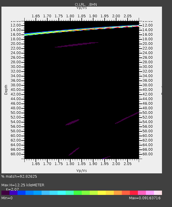
| Estimated Moho Depth: |
12.25 km |
| Estimated Crust Vp/Vs: |
2.07 |
| Assumed Crust Vp: |
6.276 km/s |
| Estimated Crust Vs: |
3.032 km/s |
| Estimated Crust Poisson's Ratio: |
0.35 |
|
| Radial Match: |
92.82625 % |
| Radial Bump: |
311 |
| Transverse Match: |
64.7167 % |
| Transverse Bump: |
400 |
| SOD ConfigId: |
319893 |
| Insert Time: |
2011-01-05 06:45:07.942 +0000 |
| GWidth: |
2.5 |
| Max Bumps: |
400 |
| Tol: |
0.001 |
|

Signal To Noise
| Channel | StoN | STA | LTA |
| CI:LRL: :BHZ:20100718T13:47:46.075027Z | 1.9682809 | 5.803326E-6 | 2.9484236E-6 |
| CI:LRL: :BHN:20100718T13:47:46.075027Z | 1.8067218 | 2.0990199E-6 | 1.1617838E-6 |
| CI:LRL: :BHE:20100718T13:47:46.075027Z | 1.090094 | 3.4083641E-6 | 3.1266698E-6 |
| Arrivals |
| Ps | 2.1 SECOND |
| PpPs | 5.9 SECOND |
| PsPs/PpSs | 8.0 SECOND |


