You are here: Home > Network List > G - GEOSCOPE Stations List
> Station MPG Montagne des Peres, French Guyana > Earthquake Result Viewer
MPG Montagne des Peres, French Guyana - Earthquake Result Viewer

| Earthquake location: |
Near Coast Of Northern Chile |
| Earthquake latitude/longitude: |
-27.3/-71.6 |
| Earthquake time(UTC): |
2023/09/15 (258) 18:07:39 GMT |
| Earthquake Depth: |
4.9 km |
| Earthquake Magnitude: |
5.7 mww |
| Earthquake Catalog/Contributor: |
NEIC PDE/us |
|
| Network: |
G GEOSCOPE |
| Station: |
MPG Montagne des Peres, French Guyana |
| Lat/Lon: |
5.11 N/52.64 W |
| Elevation: |
147 m |
|
| Distance: |
37.1 deg |
| Az: |
32.384 deg |
| Baz: |
208.579 deg |
| Ray Param: |
0.07637429 |
| Estimated Moho Depth: |
11.25 km |
| Estimated Crust Vp/Vs: |
2.02 |
| Assumed Crust Vp: |
6.472 km/s |
| Estimated Crust Vs: |
3.208 km/s |
| Estimated Crust Poisson's Ratio: |
0.34 |
|
| Radial Match: |
89.87775 % |
| Radial Bump: |
400 |
| Transverse Match: |
73.76792 % |
| Transverse Bump: |
400 |
| SOD ConfigId: |
31937991 |
| Insert Time: |
2023-09-29 18:15:52.222 +0000 |
| GWidth: |
2.5 |
| Max Bumps: |
400 |
| Tol: |
0.001 |
|
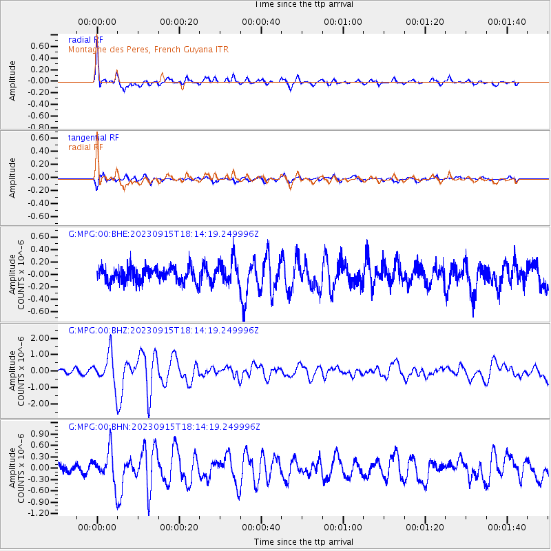
Signal To Noise
| Channel | StoN | STA | LTA |
| G:MPG:00:BHZ:20230915T18:14:19.249996Z | 5.338868 | 9.918101E-7 | 1.857716E-7 |
| G:MPG:00:BHN:20230915T18:14:19.249996Z | 4.771185 | 4.4089944E-7 | 9.240879E-8 |
| G:MPG:00:BHE:20230915T18:14:19.249996Z | 1.7002587 | 1.9545448E-7 | 1.14955725E-7 |
| Arrivals |
| Ps | 1.9 SECOND |
| PpPs | 4.9 SECOND |
| PsPs/PpSs | 6.8 SECOND |


