You are here: Home > Network List > CI - Caltech Regional Seismic Network Stations List
> Station SMM Simmler, CA, USA > Earthquake Result Viewer
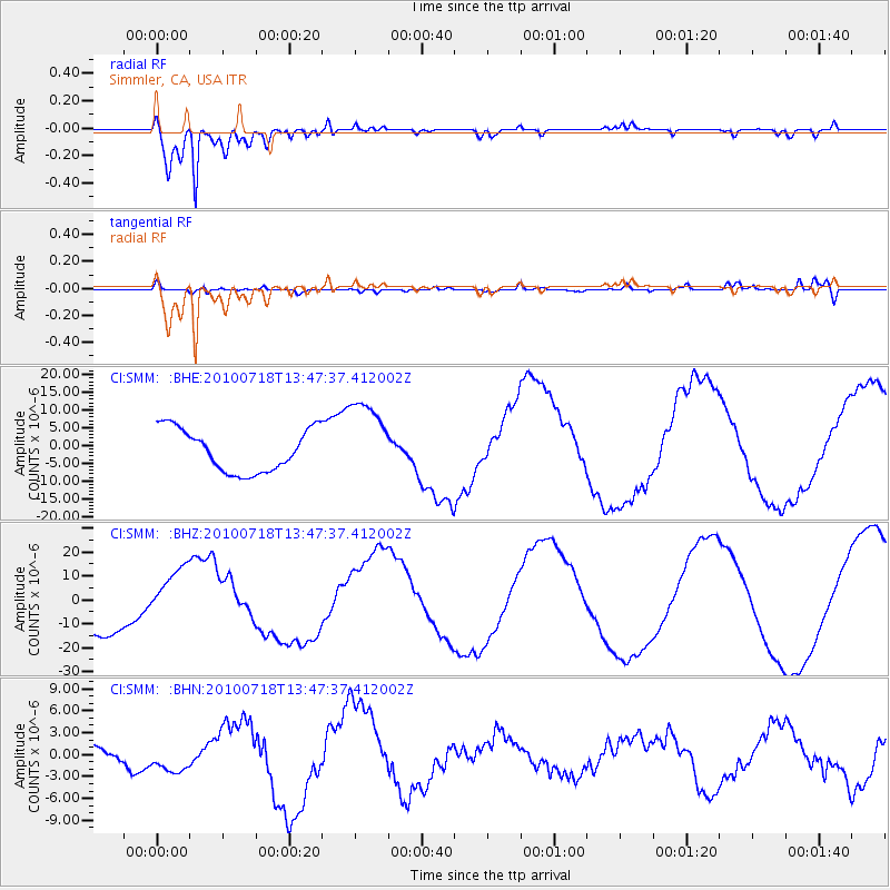
SMM Simmler, CA, USA - Earthquake Result Viewer
*The percent match for this event was below the threshold and hence no stack was calculated.
| Earthquake location: |
New Britain Region, P.N.G. |
| Earthquake latitude/longitude: |
-5.9/150.6 |
| Earthquake time(UTC): |
2010/07/18 (199) 13:34:59 GMT |
| Earthquake Depth: |
35 km |
| Earthquake Magnitude: |
6.1 MB, 7.3 MS, 7.3 MW, 7.3 MW |
| Earthquake Catalog/Contributor: |
WHDF/NEIC |
|
| Network: |
CI Caltech Regional Seismic Network |
| Station: |
SMM Simmler, CA, USA |
| Lat/Lon: |
35.31 N/120.00 W |
| Elevation: |
599 m |
|
| Distance: |
92.9 deg |
| Az: |
54.968 deg |
| Baz: |
264.841 deg |
| Ray Param: |
$rayparam |
*The percent match for this event was below the threshold and hence was not used in the summary stack. |
|
| Radial Match: |
94.287544 % |
| Radial Bump: |
360 |
| Transverse Match: |
27.874632 % |
| Transverse Bump: |
400 |
| SOD ConfigId: |
319893 |
| Insert Time: |
2011-01-05 06:46:49.580 +0000 |
| GWidth: |
2.5 |
| Max Bumps: |
400 |
| Tol: |
0.001 |
|
Signal To Noise
| Channel | StoN | STA | LTA |
| CI:SMM: :BHZ:20100718T13:47:37.412002Z | 1.4107077 | 1.162519E-5 | 8.24068E-6 |
| CI:SMM: :BHN:20100718T13:47:37.412002Z | 0.885518 | 1.7228067E-6 | 1.9455356E-6 |
| CI:SMM: :BHE:20100718T13:47:37.412002Z | 1.90888 | 1.1479033E-5 | 6.013491E-6 |
| Arrivals |
| Ps | |
| PpPs | |
| PsPs/PpSs | |


