You are here: Home > Network List > CI - Caltech Regional Seismic Network Stations List
> Station DEC Green Verdugo Microwave Site, Sunland, CA, USA > Earthquake Result Viewer
DEC Green Verdugo Microwave Site, Sunland, CA, USA - Earthquake Result Viewer
| Earthquake location: |
New Britain Region, P.N.G. |
| Earthquake latitude/longitude: |
-5.9/150.6 |
| Earthquake time(UTC): |
2010/07/18 (199) 13:34:59 GMT |
| Earthquake Depth: |
35 km |
| Earthquake Magnitude: |
6.1 MB, 7.3 MS, 7.3 MW, 7.3 MW |
| Earthquake Catalog/Contributor: |
WHDF/NEIC |
|
| Network: |
CI Caltech Regional Seismic Network |
| Station: |
DEC Green Verdugo Microwave Site, Sunland, CA, USA |
| Lat/Lon: |
34.25 N/118.33 W |
| Elevation: |
519 m |
|
| Distance: |
94.2 deg |
| Az: |
56.137 deg |
| Baz: |
265.713 deg |
| Ray Param: |
0.041088603 |
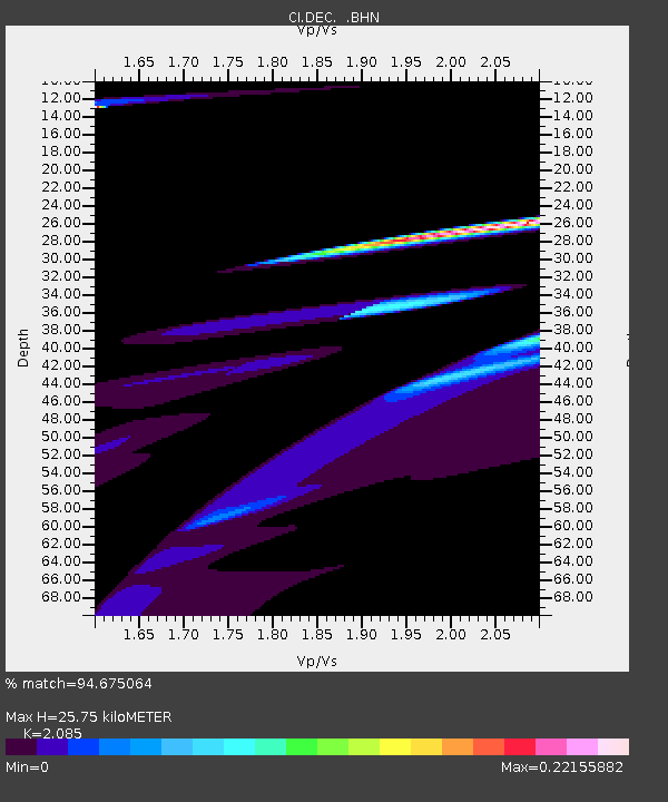
| Estimated Moho Depth: |
25.75 km |
| Estimated Crust Vp/Vs: |
2.09 |
| Assumed Crust Vp: |
6.1 km/s |
| Estimated Crust Vs: |
2.926 km/s |
| Estimated Crust Poisson's Ratio: |
0.35 |
|
| Radial Match: |
94.675064 % |
| Radial Bump: |
400 |
| Transverse Match: |
46.865078 % |
| Transverse Bump: |
352 |
| SOD ConfigId: |
319893 |
| Insert Time: |
2011-01-05 06:47:05.065 +0000 |
| GWidth: |
2.5 |
| Max Bumps: |
400 |
| Tol: |
0.001 |
|

Signal To Noise
| Channel | StoN | STA | LTA |
| CI:DEC: :BHZ:20100718T13:47:43.247024Z | 1.3853357 | 6.6496787E-6 | 4.800049E-6 |
| CI:DEC: :BHN:20100718T13:47:43.247024Z | 1.0304408 | 1.8806971E-6 | 1.8251385E-6 |
| CI:DEC: :BHE:20100718T13:47:43.247024Z | 2.540447 | 6.8960912E-6 | 2.7145186E-6 |
| Arrivals |
| Ps | 4.7 SECOND |
| PpPs | 13 SECOND |
| PsPs/PpSs | 17 SECOND |


