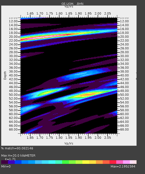
UGM GEOFON Station Wanagama, Indonesia - Earthquake Result Viewer
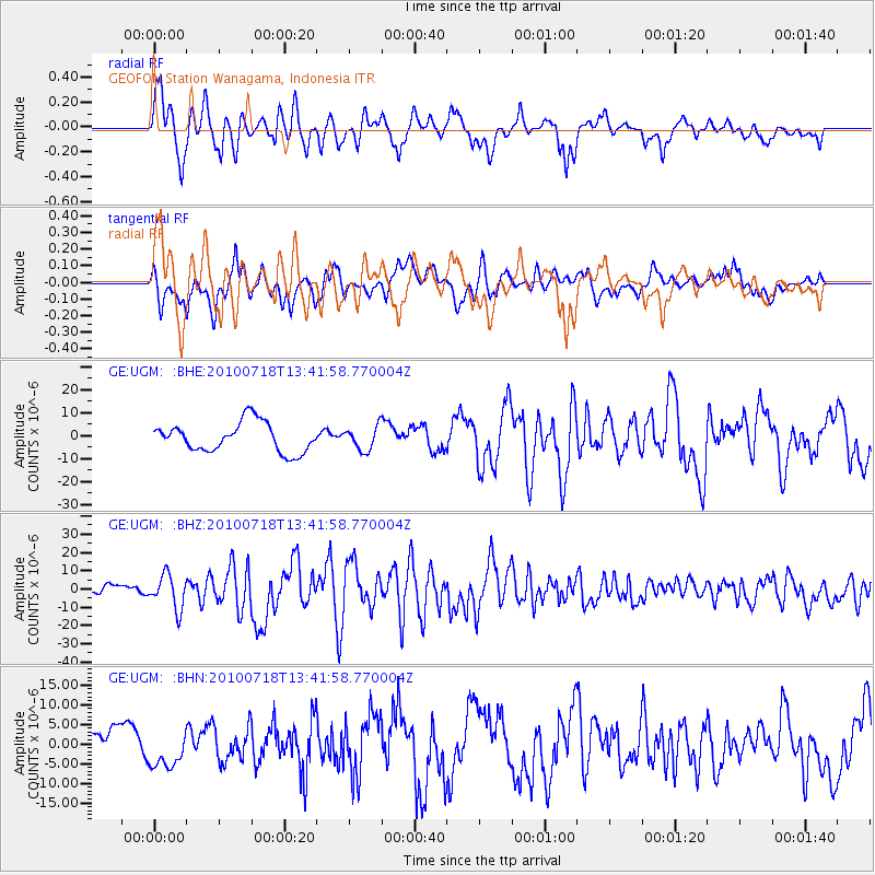
Earthquake location: New Britain Region, P.N.G.
Earthquake latitude/longitude: -5.9/150.6
Earthquake time(UTC): 2010/07/18 (199) 13:34:59 GMT
Earthquake Depth: 35 km
Earthquake Magnitude: 6.1 MB, 7.3 MS, 7.3 MW, 7.3 MW
Earthquake Catalog/Contributor: WHDF/NEIC
Network: GE GEOFON
Station: UGM GEOFON Station Wanagama, Indonesia
Lat/Lon: 7.91 S/110.52 E
Elevation: 350 m
Distance: 39.8 deg
Az: 264.783 deg
Baz: 89.783 deg
Ray Param: 0.074692175
Estimated Moho Depth: 20.0 km
Estimated Crust Vp/Vs: 1.71
Assumed Crust Vp: 6.343 km/s
Estimated Crust Vs: 3.71 km/s
Estimated Crust Poisson's Ratio: 0.24
Radial Match: 80.082146 %
Radial Bump: 400
Transverse Match: 70.48278 %
Transverse Bump: 400
SOD ConfigId: 319893
Insert Time: 2011-01-05 06:48:53.797 +0000
GWidth: 2.5
Max Bumps: 400
Tol: 0.001

Signal To Noise

ChannelStoNSTALTA
GE:UGM: :BHZ:20100718T13:41:58.770004Z4.0489559.173499E-62.2656461E-6
GE:UGM: :BHN:20100718T13:41:58.770004Z1.22463875.0998715E-64.1643884E-6
GE:UGM: :BHE:20100718T13:41:58.770004Z0.8032655.131061E-66.387756E-6
Arrivals
Ps2.4 SECOND
PpPs8.0 SECOND
PsPs/PpSs10 SECOND