You are here: Home > Network List > US - United States National Seismic Network Stations List
> Station HAWA Hanford, Washington, USA > Earthquake Result Viewer
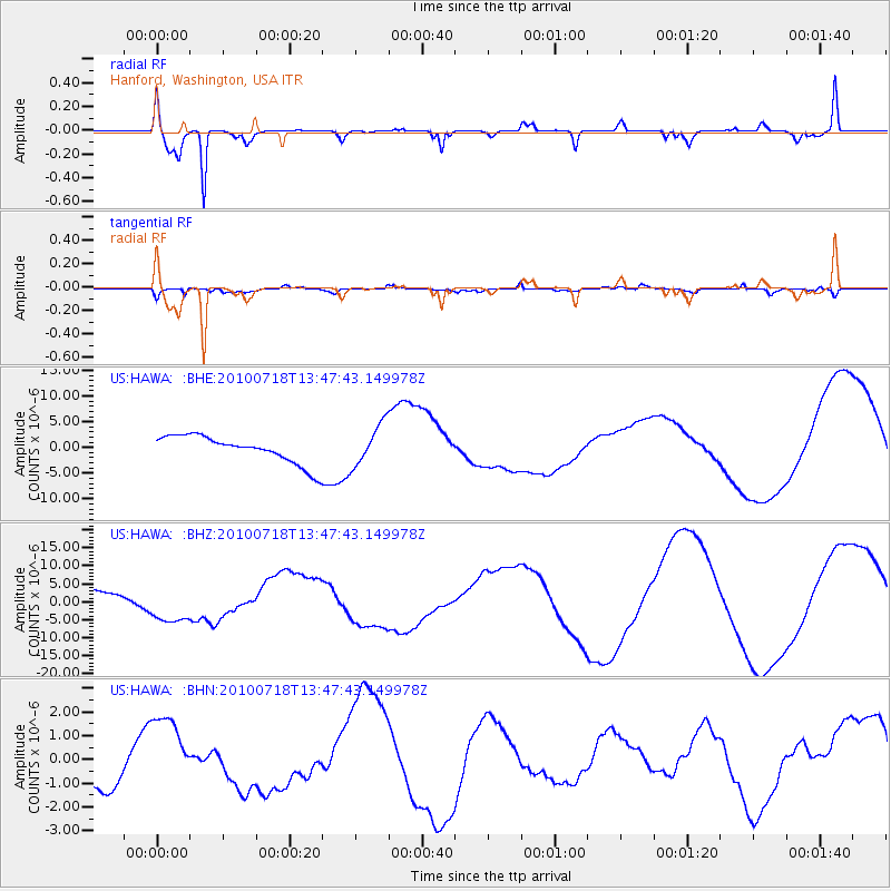
HAWA Hanford, Washington, USA - Earthquake Result Viewer
*The percent match for this event was below the threshold and hence no stack was calculated.
| Earthquake location: |
New Britain Region, P.N.G. |
| Earthquake latitude/longitude: |
-5.9/150.6 |
| Earthquake time(UTC): |
2010/07/18 (199) 13:34:59 GMT |
| Earthquake Depth: |
35 km |
| Earthquake Magnitude: |
6.1 MB, 7.3 MS, 7.3 MW, 7.3 MW |
| Earthquake Catalog/Contributor: |
WHDF/NEIC |
|
| Network: |
US United States National Seismic Network |
| Station: |
HAWA Hanford, Washington, USA |
| Lat/Lon: |
46.39 N/119.53 W |
| Elevation: |
364 m |
|
| Distance: |
94.2 deg |
| Az: |
43.945 deg |
| Baz: |
265.827 deg |
| Ray Param: |
$rayparam |
*The percent match for this event was below the threshold and hence was not used in the summary stack. |
|
| Radial Match: |
89.54311 % |
| Radial Bump: |
348 |
| Transverse Match: |
53.36705 % |
| Transverse Bump: |
400 |
| SOD ConfigId: |
319893 |
| Insert Time: |
2011-01-05 06:52:29.278 +0000 |
| GWidth: |
2.5 |
| Max Bumps: |
400 |
| Tol: |
0.001 |
|
Signal To Noise
| Channel | StoN | STA | LTA |
| US:HAWA: :BHZ:20100718T13:47:43.149978Z | 3.186753 | 5.6175336E-6 | 1.7627766E-6 |
| US:HAWA: :BHN:20100718T13:47:43.149978Z | 2.3532777 | 1.6854915E-6 | 7.1623145E-7 |
| US:HAWA: :BHE:20100718T13:47:43.149978Z | 1.4907467 | 4.030279E-6 | 2.70353E-6 |
| Arrivals |
| Ps | |
| PpPs | |
| PsPs/PpSs | |


