You are here: Home > Network List > UW - Pacific Northwest Regional Seismic Network Stations List
> Station UMAT Pilot Rock, OR, USA > Earthquake Result Viewer
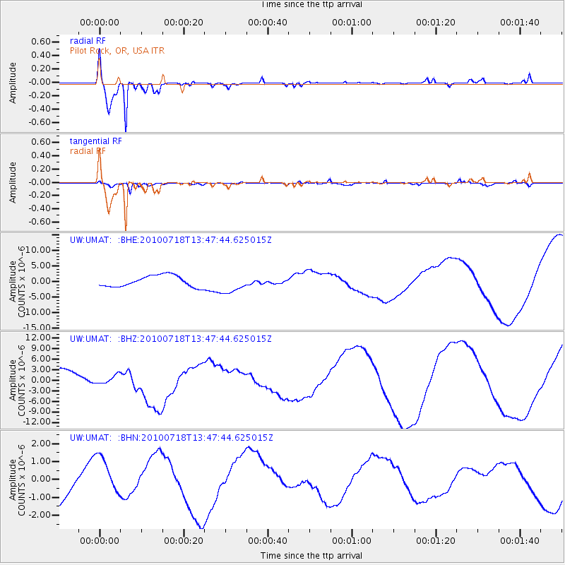
UMAT Pilot Rock, OR, USA - Earthquake Result Viewer
*The percent match for this event was below the threshold and hence no stack was calculated.
| Earthquake location: |
New Britain Region, P.N.G. |
| Earthquake latitude/longitude: |
-5.9/150.6 |
| Earthquake time(UTC): |
2010/07/18 (199) 13:34:59 GMT |
| Earthquake Depth: |
35 km |
| Earthquake Magnitude: |
6.1 MB, 7.3 MS, 7.3 MW, 7.3 MW |
| Earthquake Catalog/Contributor: |
WHDF/NEIC |
|
| Network: |
UW Pacific Northwest Regional Seismic Network |
| Station: |
UMAT Pilot Rock, OR, USA |
| Lat/Lon: |
45.29 N/118.96 W |
| Elevation: |
1318 m |
|
| Distance: |
94.5 deg |
| Az: |
45.076 deg |
| Baz: |
266.151 deg |
| Ray Param: |
$rayparam |
*The percent match for this event was below the threshold and hence was not used in the summary stack. |
|
| Radial Match: |
96.03126 % |
| Radial Bump: |
258 |
| Transverse Match: |
76.70259 % |
| Transverse Bump: |
387 |
| SOD ConfigId: |
319893 |
| Insert Time: |
2011-01-05 06:53:15.116 +0000 |
| GWidth: |
2.5 |
| Max Bumps: |
400 |
| Tol: |
0.001 |
|
Signal To Noise
| Channel | StoN | STA | LTA |
| UW:UMAT: :BHZ:20100718T13:47:44.625015Z | 0.6499914 | 1.1918918E-6 | 1.8337039E-6 |
| UW:UMAT: :BHN:20100718T13:47:44.625015Z | 1.0175407 | 1.1886226E-6 | 1.1681328E-6 |
| UW:UMAT: :BHE:20100718T13:47:44.625015Z | 1.6887722 | 3.0601516E-6 | 1.812057E-6 |
| Arrivals |
| Ps | |
| PpPs | |
| PsPs/PpSs | |


