You are here: Home > Network List > AK - Alaska Regional Network Stations List
> Station K13K Kusilvak Mountain, AK, USA > Earthquake Result Viewer
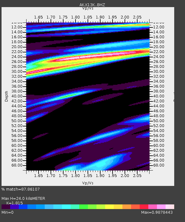
K13K Kusilvak Mountain, AK, USA - Earthquake Result Viewer
| Earthquake location: |
Northeast Of Taiwan |
| Earthquake latitude/longitude: |
26.4/125.3 |
| Earthquake time(UTC): |
2023/09/18 (261) 13:21:23 GMT |
| Earthquake Depth: |
183 km |
| Earthquake Magnitude: |
6.3 mww |
| Earthquake Catalog/Contributor: |
NEIC PDE/us |
|
| Network: |
AK Alaska Regional Network |
| Station: |
K13K Kusilvak Mountain, AK, USA |
| Lat/Lon: |
61.93 N/164.66 W |
| Elevation: |
204 m |
|
| Distance: |
57.7 deg |
| Az: |
31.745 deg |
| Baz: |
265.911 deg |
| Ray Param: |
0.0627396 |
| Estimated Moho Depth: |
24.0 km |
| Estimated Crust Vp/Vs: |
1.82 |
| Assumed Crust Vp: |
6.1 km/s |
| Estimated Crust Vs: |
3.361 km/s |
| Estimated Crust Poisson's Ratio: |
0.28 |
|
| Radial Match: |
87.86107 % |
| Radial Bump: |
390 |
| Transverse Match: |
53.60905 % |
| Transverse Bump: |
400 |
| SOD ConfigId: |
31937991 |
| Insert Time: |
2023-10-02 13:25:30.281 +0000 |
| GWidth: |
2.5 |
| Max Bumps: |
400 |
| Tol: |
0.001 |
|

Signal To Noise
| Channel | StoN | STA | LTA |
| AK:K13K: :BHZ:20230918T13:30:24.180015Z | 5.7976646 | 1.1215075E-6 | 1.9344124E-7 |
| AK:K13K: :BHN:20230918T13:30:24.180015Z | 1.4997737 | 4.0041544E-7 | 2.669839E-7 |
| AK:K13K: :BHE:20230918T13:30:24.180015Z | 3.467811 | 5.8152114E-7 | 1.6769111E-7 |
| Arrivals |
| Ps | 3.3 SECOND |
| PpPs | 11 SECOND |
| PsPs/PpSs | 14 SECOND |


