You are here: Home > Network List > AV - Alaska Volcano Observatory Stations List
> Station SPCL Chakachamna Lake, Mount Spurr, Alaska > Earthquake Result Viewer
SPCL Chakachamna Lake, Mount Spurr, Alaska - Earthquake Result Viewer
| Earthquake location: |
Northeast Of Taiwan |
| Earthquake latitude/longitude: |
26.4/125.3 |
| Earthquake time(UTC): |
2023/09/18 (261) 13:21:23 GMT |
| Earthquake Depth: |
183 km |
| Earthquake Magnitude: |
6.3 mww |
| Earthquake Catalog/Contributor: |
NEIC PDE/us |
|
| Network: |
AV Alaska Volcano Observatory |
| Station: |
SPCL Chakachamna Lake, Mount Spurr, Alaska |
| Lat/Lon: |
61.20 N/152.34 W |
| Elevation: |
1274 m |
|
| Distance: |
63.6 deg |
| Az: |
32.415 deg |
| Baz: |
277.063 deg |
| Ray Param: |
0.058937125 |
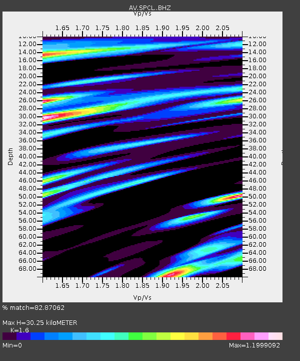
| Estimated Moho Depth: |
30.25 km |
| Estimated Crust Vp/Vs: |
1.60 |
| Assumed Crust Vp: |
6.566 km/s |
| Estimated Crust Vs: |
4.104 km/s |
| Estimated Crust Poisson's Ratio: |
0.18 |
|
| Radial Match: |
82.87062 % |
| Radial Bump: |
400 |
| Transverse Match: |
70.48408 % |
| Transverse Bump: |
400 |
| SOD ConfigId: |
31937991 |
| Insert Time: |
2023-10-02 13:30:34.151 +0000 |
| GWidth: |
2.5 |
| Max Bumps: |
400 |
| Tol: |
0.001 |
|

Signal To Noise
| Channel | StoN | STA | LTA |
| AV:SPCL: :BHZ:20230918T13:31:03.980002Z | 7.4434905 | 2.273706E-6 | 3.0546235E-7 |
| AV:SPCL: :BHN:20230918T13:31:03.980002Z | 1.6022233 | 6.918585E-7 | 4.3181151E-7 |
| AV:SPCL: :BHE:20230918T13:31:03.980002Z | 2.9709926 | 1.113343E-6 | 3.7473777E-7 |
| Arrivals |
| Ps | 2.9 SECOND |
| PpPs | 11 SECOND |
| PsPs/PpSs | 14 SECOND |


