You are here: Home > Network List > CN - Canadian National Seismograph Network Stations List
> Station INK INUVIK, NT > Earthquake Result Viewer
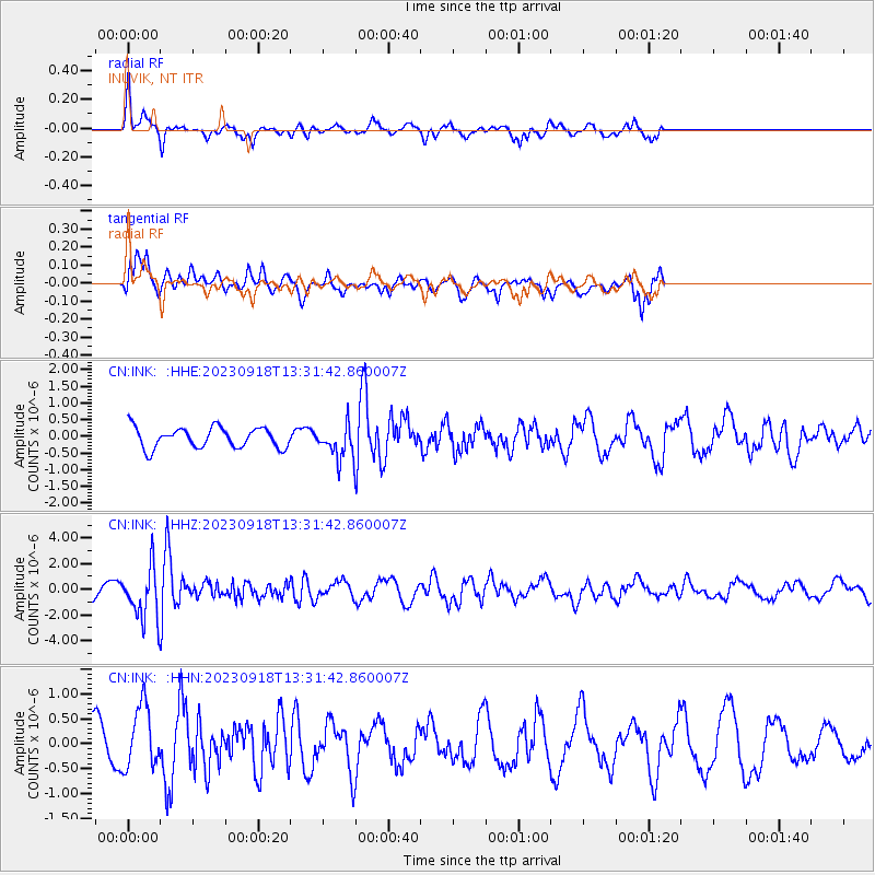
INK INUVIK, NT - Earthquake Result Viewer
*The percent match for this event was below the threshold and hence no stack was calculated.
| Earthquake location: |
Northeast Of Taiwan |
| Earthquake latitude/longitude: |
26.4/125.3 |
| Earthquake time(UTC): |
2023/09/18 (261) 13:21:23 GMT |
| Earthquake Depth: |
183 km |
| Earthquake Magnitude: |
6.3 mww |
| Earthquake Catalog/Contributor: |
NEIC PDE/us |
|
| Network: |
CN Canadian National Seismograph Network |
| Station: |
INK INUVIK, NT |
| Lat/Lon: |
68.31 N/133.53 W |
| Elevation: |
44 m |
|
| Distance: |
69.7 deg |
| Az: |
22.881 deg |
| Baz: |
290.328 deg |
| Ray Param: |
$rayparam |
*The percent match for this event was below the threshold and hence was not used in the summary stack. |
|
| Radial Match: |
74.3141 % |
| Radial Bump: |
359 |
| Transverse Match: |
70.67291 % |
| Transverse Bump: |
400 |
| SOD ConfigId: |
31937991 |
| Insert Time: |
2023-10-02 13:35:02.249 +0000 |
| GWidth: |
2.5 |
| Max Bumps: |
400 |
| Tol: |
0.001 |
|
Signal To Noise
| Channel | StoN | STA | LTA |
| CN:INK: :HHZ:20230918T13:31:42.860007Z | 2.539406 | 1.9419226E-6 | 7.647153E-7 |
| CN:INK: :HHN:20230918T13:31:42.860007Z | 1.5829794 | 6.2363074E-7 | 3.939601E-7 |
| CN:INK: :HHE:20230918T13:31:42.860007Z | 1.6198279 | 4.964235E-7 | 3.064668E-7 |
| Arrivals |
| Ps | |
| PpPs | |
| PsPs/PpSs | |


