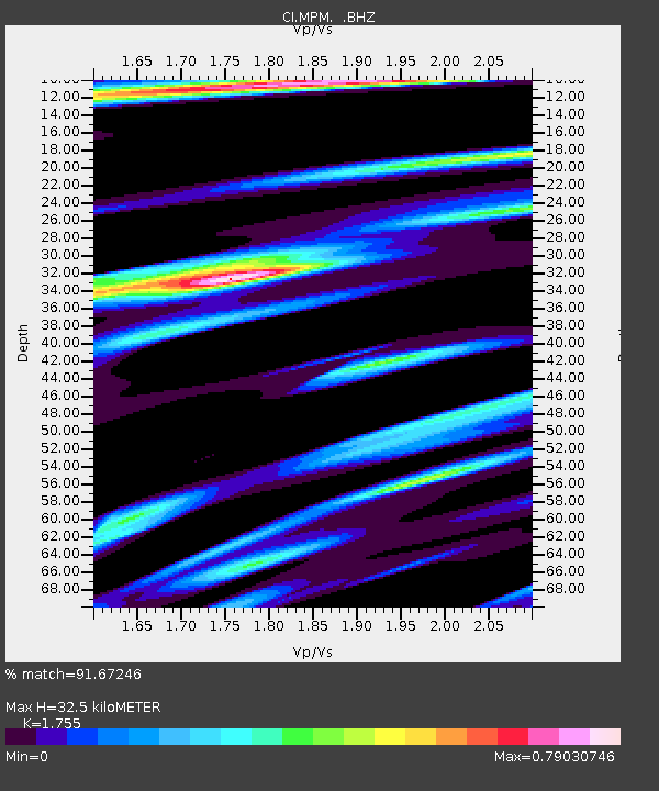
MPM Manuel Prospect Mine, California, USA - Earthquake Result Viewer
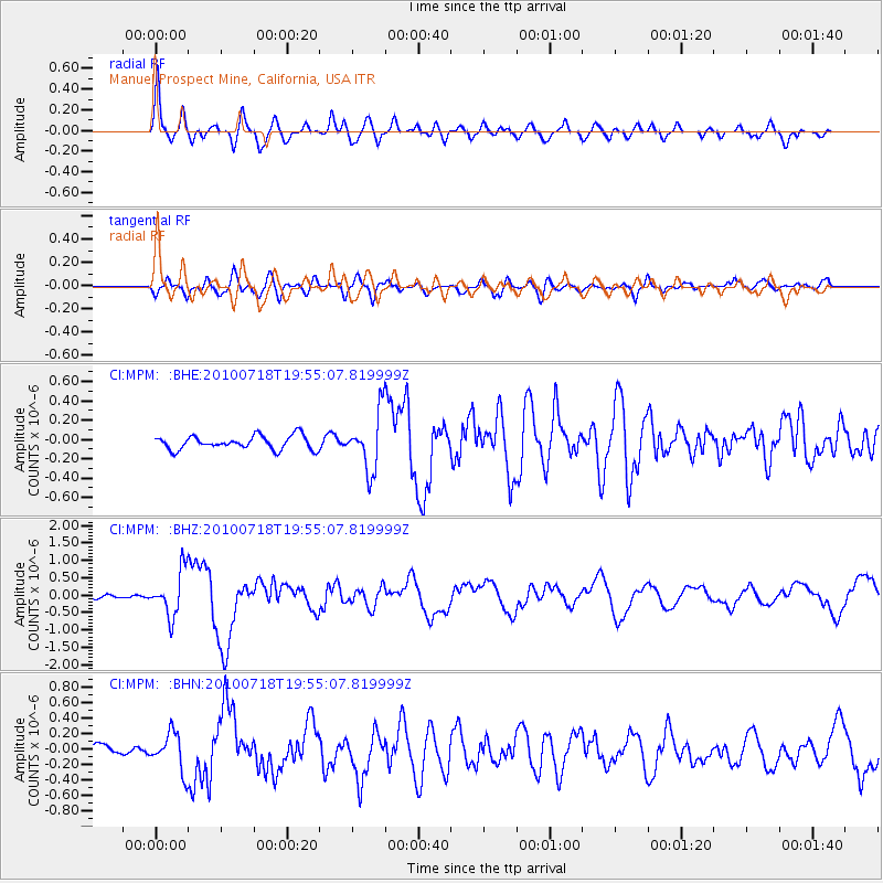
Earthquake location: Fox Islands, Aleutian Islands
Earthquake latitude/longitude: 52.8/-169.7
Earthquake time(UTC): 2010/07/18 (199) 19:48:04 GMT
Earthquake Depth: 10 km
Earthquake Magnitude: 5.6 MB, 5.6 MS, 6.0 MW, 6.0 MW
Earthquake Catalog/Contributor: WHDF/NEIC
Network: CI Caltech Regional Seismic Network
Station: MPM Manuel Prospect Mine, California, USA
Lat/Lon: 36.06 N/117.49 W
Elevation: 185 m
Distance: 39.9 deg
Az: 93.46 deg
Baz: 311.608 deg
Ray Param: 0.07470103
Estimated Moho Depth: 32.5 km
Estimated Crust Vp/Vs: 1.75
Assumed Crust Vp: 6.279 km/s
Estimated Crust Vs: 3.578 km/s
Estimated Crust Poisson's Ratio: 0.26
Radial Match: 91.67246 %
Radial Bump: 400
Transverse Match: 76.78601 %
Transverse Bump: 400
SOD ConfigId: 319893
Insert Time: 2011-01-05 07:00:43.207 +0000
GWidth: 2.5
Max Bumps: 400
Tol: 0.001

Signal To Noise

ChannelStoNSTALTA
CI:MPM: :BHZ:20100718T19:55:07.819999Z7.44946866.4626363E-78.675298E-8
CI:MPM: :BHN:20100718T19:55:07.819999Z3.1383982.4210928E-77.714423E-8
CI:MPM: :BHE:20100718T19:55:07.819999Z4.22119432.987085E-77.076398E-8
Arrivals
Ps4.2 SECOND
PpPs13 SECOND
PsPs/PpSs18 SECOND