You are here: Home > Network List > US - United States National Seismic Network Stations List
> Station DGMT Dagmar, Montana, USA > Earthquake Result Viewer
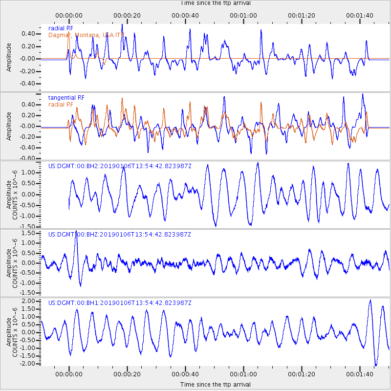
DGMT Dagmar, Montana, USA - Earthquake Result Viewer
*The percent match for this event was below the threshold and hence no stack was calculated.
| Earthquake location: |
Iran-Iraq Border Region |
| Earthquake latitude/longitude: |
34.1/45.7 |
| Earthquake time(UTC): |
2019/01/06 (006) 13:42:01 GMT |
| Earthquake Depth: |
25 km |
| Earthquake Magnitude: |
5.8 mb |
| Earthquake Catalog/Contributor: |
NEIC PDE/us |
|
| Network: |
US United States National Seismic Network |
| Station: |
DGMT Dagmar, Montana, USA |
| Lat/Lon: |
48.47 N/104.20 W |
| Elevation: |
0.0 m |
|
| Distance: |
93.5 deg |
| Az: |
340.446 deg |
| Baz: |
24.657 deg |
| Ray Param: |
$rayparam |
*The percent match for this event was below the threshold and hence was not used in the summary stack. |
|
| Radial Match: |
60.276184 % |
| Radial Bump: |
379 |
| Transverse Match: |
41.62596 % |
| Transverse Bump: |
354 |
| SOD ConfigId: |
3201911 |
| Insert Time: |
2019-01-20 13:59:38.513 +0000 |
| GWidth: |
2.5 |
| Max Bumps: |
400 |
| Tol: |
0.001 |
|
Signal To Noise
| Channel | StoN | STA | LTA |
| US:DGMT:00:BHZ:20190106T13:54:42.823987Z | 2.5792117 | 7.7005427E-7 | 2.9856187E-7 |
| US:DGMT:00:BH1:20190106T13:54:42.823987Z | 2.2956448 | 9.230714E-7 | 4.0209682E-7 |
| US:DGMT:00:BH2:20190106T13:54:42.823987Z | 1.0738411 | 5.7277146E-7 | 5.3338573E-7 |
| Arrivals |
| Ps | |
| PpPs | |
| PsPs/PpSs | |


