You are here: Home > Network List > LB - Leo Brady Network Stations List
> Station TPH Tonopah, Nevada, USA > Earthquake Result Viewer
TPH Tonopah, Nevada, USA - Earthquake Result Viewer
| Earthquake location: |
Fox Islands, Aleutian Islands |
| Earthquake latitude/longitude: |
52.8/-169.7 |
| Earthquake time(UTC): |
2010/07/18 (199) 19:48:04 GMT |
| Earthquake Depth: |
10 km |
| Earthquake Magnitude: |
5.6 MB, 5.6 MS, 6.0 MW, 6.0 MW |
| Earthquake Catalog/Contributor: |
WHDF/NEIC |
|
| Network: |
LB Leo Brady Network |
| Station: |
TPH Tonopah, Nevada, USA |
| Lat/Lon: |
38.08 N/117.22 W |
| Elevation: |
1883 m |
|
| Distance: |
38.8 deg |
| Az: |
90.832 deg |
| Baz: |
309.736 deg |
| Ray Param: |
0.07537168 |
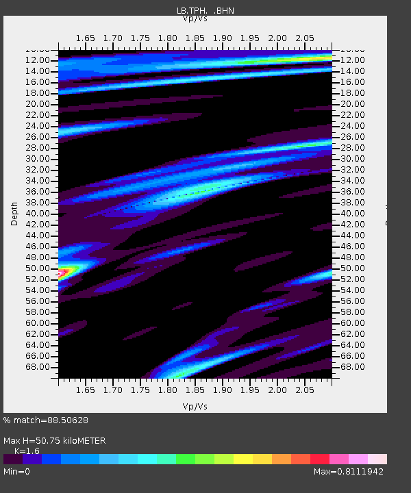
| Estimated Moho Depth: |
50.75 km |
| Estimated Crust Vp/Vs: |
1.60 |
| Assumed Crust Vp: |
6.276 km/s |
| Estimated Crust Vs: |
3.922 km/s |
| Estimated Crust Poisson's Ratio: |
0.18 |
|
| Radial Match: |
88.50628 % |
| Radial Bump: |
400 |
| Transverse Match: |
63.805412 % |
| Transverse Bump: |
400 |
| SOD ConfigId: |
319893 |
| Insert Time: |
2011-01-05 07:09:02.698 +0000 |
| GWidth: |
2.5 |
| Max Bumps: |
400 |
| Tol: |
0.001 |
|

Signal To Noise
| Channel | StoN | STA | LTA |
| LB:TPH: :BHZ:20100718T19:54:58.236014Z | 18.45545 | 8.049802E-7 | 4.3617476E-8 |
| LB:TPH: :BHN:20100718T19:54:58.236014Z | 5.506829 | 3.3272823E-7 | 6.042103E-8 |
| LB:TPH: :BHE:20100718T19:54:58.236014Z | 5.753641 | 4.0413082E-7 | 7.023914E-8 |
| Arrivals |
| Ps | 5.2 SECOND |
| PpPs | 19 SECOND |
| PsPs/PpSs | 25 SECOND |


