You are here: Home > Network List > AE - Arizona Broadband Seismic Network Stations List
> Station W18A Petrified Forest, AZ, USA > Earthquake Result Viewer
W18A Petrified Forest, AZ, USA - Earthquake Result Viewer
| Earthquake location: |
Central East Pacific Rise |
| Earthquake latitude/longitude: |
-4.5/-105.8 |
| Earthquake time(UTC): |
2023/09/20 (263) 14:45:59 GMT |
| Earthquake Depth: |
10 km |
| Earthquake Magnitude: |
6.0 Mww |
| Earthquake Catalog/Contributor: |
NEIC PDE/us |
|
| Network: |
AE Arizona Broadband Seismic Network |
| Station: |
W18A Petrified Forest, AZ, USA |
| Lat/Lon: |
35.12 N/109.74 W |
| Elevation: |
1750 m |
|
| Distance: |
39.6 deg |
| Az: |
354.876 deg |
| Baz: |
173.765 deg |
| Ray Param: |
0.074873045 |
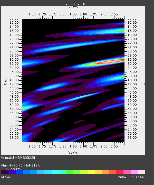
| Estimated Moho Depth: |
30.75 km |
| Estimated Crust Vp/Vs: |
2.03 |
| Assumed Crust Vp: |
6.496 km/s |
| Estimated Crust Vs: |
3.196 km/s |
| Estimated Crust Poisson's Ratio: |
0.34 |
|
| Radial Match: |
89.535225 % |
| Radial Bump: |
299 |
| Transverse Match: |
73.97939 % |
| Transverse Bump: |
353 |
| SOD ConfigId: |
31937991 |
| Insert Time: |
2023-10-04 14:47:53.642 +0000 |
| GWidth: |
2.5 |
| Max Bumps: |
400 |
| Tol: |
0.001 |
|

Signal To Noise
| Channel | StoN | STA | LTA |
| AE:W18A: :HHZ:20230920T14:52:59.919997Z | 2.531191 | 6.2384566E-7 | 2.464633E-7 |
| AE:W18A: :HHN:20230920T14:52:59.919997Z | 2.0492682 | 4.4725346E-7 | 2.1825032E-7 |
| AE:W18A: :HHE:20230920T14:52:59.919997Z | 1.2319341 | 1.718663E-7 | 1.3950934E-7 |
| Arrivals |
| Ps | 5.2 SECOND |
| PpPs | 13 SECOND |
| PsPs/PpSs | 19 SECOND |


