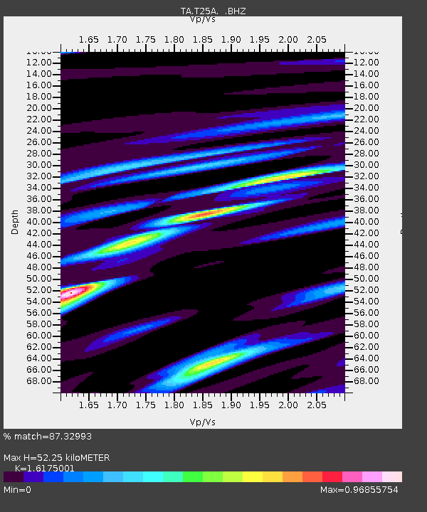
T25A Trinidad, CO, USA - Earthquake Result Viewer

Earthquake location: Fox Islands, Aleutian Islands
Earthquake latitude/longitude: 52.8/-169.7
Earthquake time(UTC): 2010/07/18 (199) 19:48:04 GMT
Earthquake Depth: 10 km
Earthquake Magnitude: 5.6 MB, 5.6 MS, 6.0 MW, 6.0 MW
Earthquake Catalog/Contributor: WHDF/NEIC
Network: TA USArray Transportable Network (new EarthScope stations)
Station: T25A Trinidad, CO, USA
Lat/Lon: 37.14 N/104.41 W
Elevation: 2017 m
Distance: 47.1 deg
Az: 82.19 deg
Baz: 311.193 deg
Ray Param: 0.0701975
Estimated Moho Depth: 52.25 km
Estimated Crust Vp/Vs: 1.62
Assumed Crust Vp: 6.316 km/s
Estimated Crust Vs: 3.905 km/s
Estimated Crust Poisson's Ratio: 0.19
Radial Match: 87.32993 %
Radial Bump: 400
Transverse Match: 78.21522 %
Transverse Bump: 400
SOD ConfigId: 319893
Insert Time: 2011-01-05 07:13:32.944 +0000
GWidth: 2.5
Max Bumps: 400
Tol: 0.001

Signal To Noise

ChannelStoNSTALTA
TA:T25A: :BHZ:20100718T19:56:05.825004Z13.5245941.1640373E-68.6068184E-8
TA:T25A: :BHN:20100718T19:56:05.825004Z5.6393114.9468673E-78.7721126E-8
TA:T25A: :BHE:20100718T19:56:05.825004Z5.80454834.1897616E-77.218066E-8
Arrivals
Ps5.5 SECOND
PpPs20 SECOND
PsPs/PpSs26 SECOND