You are here: Home > Network List > US - United States National Seismic Network Stations List
> Station MSO Missoula, Montana, USA > Earthquake Result Viewer
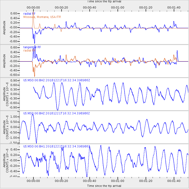
MSO Missoula, Montana, USA - Earthquake Result Viewer
*The percent match for this event was below the threshold and hence no stack was calculated.
| Earthquake location: |
Komandorskiye Ostrova Region |
| Earthquake latitude/longitude: |
54.8/164.8 |
| Earthquake time(UTC): |
2018/12/21 (355) 16:24:16 GMT |
| Earthquake Depth: |
10 km |
| Earthquake Magnitude: |
5.0 Mww |
| Earthquake Catalog/Contributor: |
NEIC PDE/us |
|
| Network: |
US United States National Seismic Network |
| Station: |
MSO Missoula, Montana, USA |
| Lat/Lon: |
46.83 N/113.94 W |
| Elevation: |
1264 m |
|
| Distance: |
49.2 deg |
| Az: |
63.665 deg |
| Baz: |
310.881 deg |
| Ray Param: |
$rayparam |
*The percent match for this event was below the threshold and hence was not used in the summary stack. |
|
| Radial Match: |
70.71491 % |
| Radial Bump: |
400 |
| Transverse Match: |
63.742924 % |
| Transverse Bump: |
400 |
| SOD ConfigId: |
3201911 |
| Insert Time: |
2019-01-20 15:40:00.322 +0000 |
| GWidth: |
2.5 |
| Max Bumps: |
400 |
| Tol: |
0.001 |
|
Signal To Noise
| Channel | StoN | STA | LTA |
| US:MSO:00:BHZ:20181221T16:32:34.398986Z | 2.1570942 | 8.2746453E-7 | 3.8360145E-7 |
| US:MSO:00:BH1:20181221T16:32:34.398986Z | 0.4783268 | 1.07610326E-7 | 2.249724E-7 |
| US:MSO:00:BH2:20181221T16:32:34.398986Z | 1.1753113 | 5.429149E-7 | 4.6193284E-7 |
| Arrivals |
| Ps | |
| PpPs | |
| PsPs/PpSs | |


