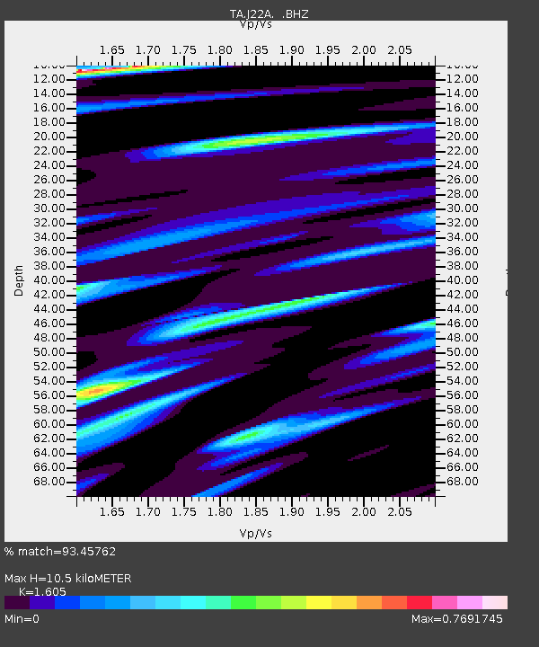
J22A Midwest, WY, USA - Earthquake Result Viewer
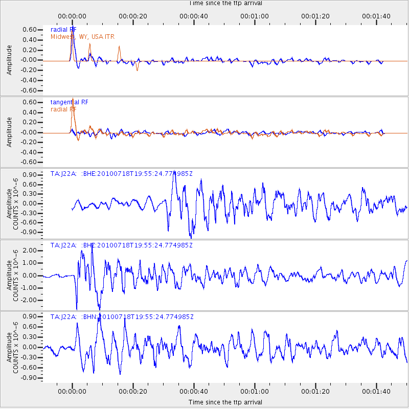
Earthquake location: Fox Islands, Aleutian Islands
Earthquake latitude/longitude: 52.8/-169.7
Earthquake time(UTC): 2010/07/18 (199) 19:48:04 GMT
Earthquake Depth: 10 km
Earthquake Magnitude: 5.6 MB, 5.6 MS, 6.0 MW, 6.0 MW
Earthquake Catalog/Contributor: WHDF/NEIC
Network: TA USArray Transportable Network (new EarthScope stations)
Station: J22A Midwest, WY, USA
Lat/Lon: 43.41 N/106.48 W
Elevation: 1587 m
Distance: 42.0 deg
Az: 76.609 deg
Baz: 305.877 deg
Ray Param: 0.07344753
Estimated Moho Depth: 10.5 km
Estimated Crust Vp/Vs: 1.61
Assumed Crust Vp: 6.178 km/s
Estimated Crust Vs: 3.849 km/s
Estimated Crust Poisson's Ratio: 0.18
Radial Match: 93.45762 %
Radial Bump: 376
Transverse Match: 65.094475 %
Transverse Bump: 400
SOD ConfigId: 319893
Insert Time: 2011-01-05 07:14:32.404 +0000
GWidth: 2.5
Max Bumps: 400
Tol: 0.001

Signal To Noise

ChannelStoNSTALTA
TA:J22A: :BHZ:20100718T19:55:24.774985Z16.1091421.1040611E-66.85363E-8
TA:J22A: :BHN:20100718T19:55:24.774985Z2.86890653.6240743E-71.263225E-7
TA:J22A: :BHE:20100718T19:55:24.774985Z5.1964054.966382E-79.5573434E-8
Arrivals
Ps1.1 SECOND
PpPs4.1 SECOND
PsPs/PpSs5.2 SECOND