You are here: Home > Network List > GM - US Geological Survey Networks Stations List
> Station IWM01 Jericho 2M Well Monitoring Station > Earthquake Result Viewer
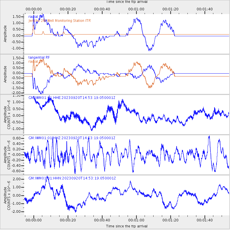
IWM01 Jericho 2M Well Monitoring Station - Earthquake Result Viewer
*The percent match for this event was below the threshold and hence no stack was calculated.
| Earthquake location: |
Central East Pacific Rise |
| Earthquake latitude/longitude: |
-4.5/-105.8 |
| Earthquake time(UTC): |
2023/09/20 (263) 14:45:59 GMT |
| Earthquake Depth: |
10 km |
| Earthquake Magnitude: |
6.0 Mww |
| Earthquake Catalog/Contributor: |
NEIC PDE/us |
|
| Network: |
GM US Geological Survey Networks |
| Station: |
IWM01 Jericho 2M Well Monitoring Station |
| Lat/Lon: |
36.73 N/96.53 W |
| Elevation: |
328 m |
|
| Distance: |
42.0 deg |
| Az: |
11.101 deg |
| Baz: |
193.822 deg |
| Ray Param: |
$rayparam |
*The percent match for this event was below the threshold and hence was not used in the summary stack. |
|
| Radial Match: |
50.593334 % |
| Radial Bump: |
400 |
| Transverse Match: |
45.98511 % |
| Transverse Bump: |
400 |
| SOD ConfigId: |
31937991 |
| Insert Time: |
2023-10-04 15:01:09.700 +0000 |
| GWidth: |
2.5 |
| Max Bumps: |
400 |
| Tol: |
0.001 |
|
Signal To Noise
| Channel | StoN | STA | LTA |
| GM:IWM01:01:HHZ:20230920T14:53:19.050001Z | 1.0232892 | 1.9253187E-7 | 1.8815001E-7 |
| GM:IWM01:01:HHN:20230920T14:53:19.050001Z | 0.74701387 | 7.1663527E-7 | 9.593333E-7 |
| GM:IWM01:01:HHE:20230920T14:53:19.050001Z | 2.0724072 | 1.1210475E-6 | 5.409398E-7 |
| Arrivals |
| Ps | |
| PpPs | |
| PsPs/PpSs | |


