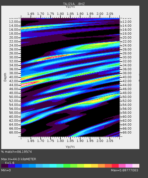
J21A Lysite, WY, USA - Earthquake Result Viewer

Earthquake location: Fox Islands, Aleutian Islands
Earthquake latitude/longitude: 52.8/-169.7
Earthquake time(UTC): 2010/07/18 (199) 19:48:04 GMT
Earthquake Depth: 10 km
Earthquake Magnitude: 5.6 MB, 5.6 MS, 6.0 MW, 6.0 MW
Earthquake Catalog/Contributor: WHDF/NEIC
Network: TA USArray Transportable Network (new EarthScope stations)
Station: J21A Lysite, WY, USA
Lat/Lon: 43.35 N/107.45 W
Elevation: 1913 m
Distance: 41.4 deg
Az: 77.311 deg
Baz: 305.739 deg
Ray Param: 0.07378673
Estimated Moho Depth: 44.0 km
Estimated Crust Vp/Vs: 1.60
Assumed Crust Vp: 6.178 km/s
Estimated Crust Vs: 3.861 km/s
Estimated Crust Poisson's Ratio: 0.18
Radial Match: 86.19574 %
Radial Bump: 400
Transverse Match: 83.61275 %
Transverse Bump: 400
SOD ConfigId: 319893
Insert Time: 2011-01-05 07:14:34.982 +0000
GWidth: 2.5
Max Bumps: 400
Tol: 0.001

Signal To Noise

ChannelStoNSTALTA
TA:J21A: :BHZ:20100718T19:55:20.42501Z12.0792657.141809E-75.912453E-8
TA:J21A: :BHN:20100718T19:55:20.42501Z3.94748333.8909462E-79.856777E-8
TA:J21A: :BHE:20100718T19:55:20.42501Z2.84820823.4282627E-71.203656E-7
Arrivals
Ps4.6 SECOND
PpPs17 SECOND
PsPs/PpSs22 SECOND