You are here: Home > Network List > N4 - Central and EAstern US Network Stations List
> Station MSTX Muleshoe, TX, USA > Earthquake Result Viewer
MSTX Muleshoe, TX, USA - Earthquake Result Viewer
| Earthquake location: |
Central East Pacific Rise |
| Earthquake latitude/longitude: |
-4.5/-105.8 |
| Earthquake time(UTC): |
2023/09/20 (263) 14:45:59 GMT |
| Earthquake Depth: |
10 km |
| Earthquake Magnitude: |
6.0 Mww |
| Earthquake Catalog/Contributor: |
NEIC PDE/us |
|
| Network: |
N4 Central and EAstern US Network |
| Station: |
MSTX Muleshoe, TX, USA |
| Lat/Lon: |
33.97 N/102.77 W |
| Elevation: |
1167 m |
|
| Distance: |
38.4 deg |
| Az: |
3.986 deg |
| Baz: |
184.782 deg |
| Ray Param: |
0.07560278 |
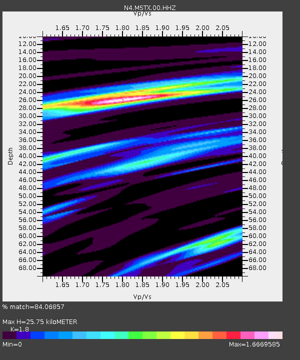
| Estimated Moho Depth: |
25.75 km |
| Estimated Crust Vp/Vs: |
1.80 |
| Assumed Crust Vp: |
6.129 km/s |
| Estimated Crust Vs: |
3.405 km/s |
| Estimated Crust Poisson's Ratio: |
0.28 |
|
| Radial Match: |
84.06857 % |
| Radial Bump: |
400 |
| Transverse Match: |
52.545383 % |
| Transverse Bump: |
400 |
| SOD ConfigId: |
31937991 |
| Insert Time: |
2023-10-04 15:04:37.078 +0000 |
| GWidth: |
2.5 |
| Max Bumps: |
400 |
| Tol: |
0.001 |
|

Signal To Noise
| Channel | StoN | STA | LTA |
| N4:MSTX:00:HHZ:20230920T14:52:49.728987Z | 2.3322082 | 4.0120304E-7 | 1.7202711E-7 |
| N4:MSTX:00:HH1:20230920T14:52:49.728987Z | 1.3825862 | 2.2602993E-7 | 1.6348342E-7 |
| N4:MSTX:00:HH2:20230920T14:52:49.728987Z | 1.9166669 | 2.9147668E-7 | 1.5207476E-7 |
| Arrivals |
| Ps | 3.6 SECOND |
| PpPs | 11 SECOND |
| PsPs/PpSs | 15 SECOND |


