You are here: Home > Network List > TA - USArray Transportable Network (new EarthScope stations) Stations List
> Station A21A Bergtoll Ranch, Theony, MT, USA > Earthquake Result Viewer
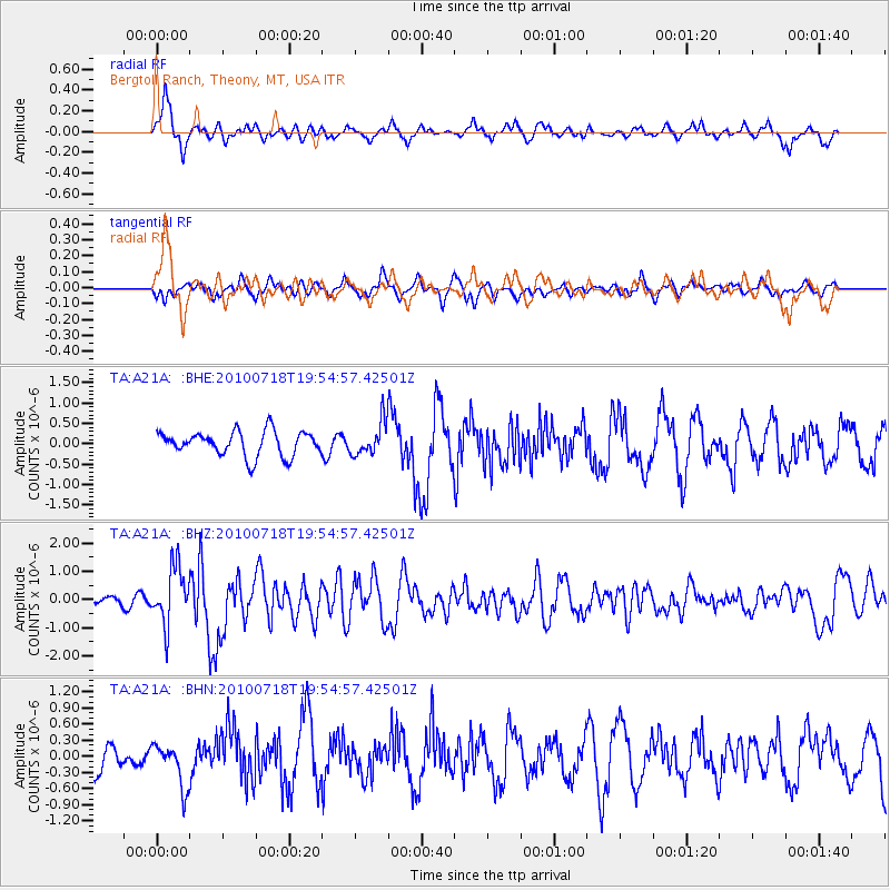
A21A Bergtoll Ranch, Theony, MT, USA - Earthquake Result Viewer
*The percent match for this event was below the threshold and hence no stack was calculated.
| Earthquake location: |
Fox Islands, Aleutian Islands |
| Earthquake latitude/longitude: |
52.8/-169.7 |
| Earthquake time(UTC): |
2010/07/18 (199) 19:48:04 GMT |
| Earthquake Depth: |
10 km |
| Earthquake Magnitude: |
5.6 MB, 5.6 MS, 6.0 MW, 6.0 MW |
| Earthquake Catalog/Contributor: |
WHDF/NEIC |
|
| Network: |
TA USArray Transportable Network (new EarthScope stations) |
| Station: |
A21A Bergtoll Ranch, Theony, MT, USA |
| Lat/Lon: |
48.99 N/106.93 W |
| Elevation: |
779 m |
|
| Distance: |
38.7 deg |
| Az: |
69.643 deg |
| Baz: |
300.239 deg |
| Ray Param: |
$rayparam |
*The percent match for this event was below the threshold and hence was not used in the summary stack. |
|
| Radial Match: |
79.28244 % |
| Radial Bump: |
400 |
| Transverse Match: |
36.582882 % |
| Transverse Bump: |
303 |
| SOD ConfigId: |
319893 |
| Insert Time: |
2011-01-05 07:15:48.825 +0000 |
| GWidth: |
2.5 |
| Max Bumps: |
400 |
| Tol: |
0.001 |
|
Signal To Noise
| Channel | StoN | STA | LTA |
| TA:A21A: :BHZ:20100718T19:54:57.42501Z | 7.6585407 | 1.0186471E-6 | 1.33008E-7 |
| TA:A21A: :BHN:20100718T19:54:57.42501Z | 1.4230416 | 4.03805E-7 | 2.837619E-7 |
| TA:A21A: :BHE:20100718T19:54:57.42501Z | 1.337078 | 4.0434708E-7 | 3.02411E-7 |
| Arrivals |
| Ps | |
| PpPs | |
| PsPs/PpSs | |


