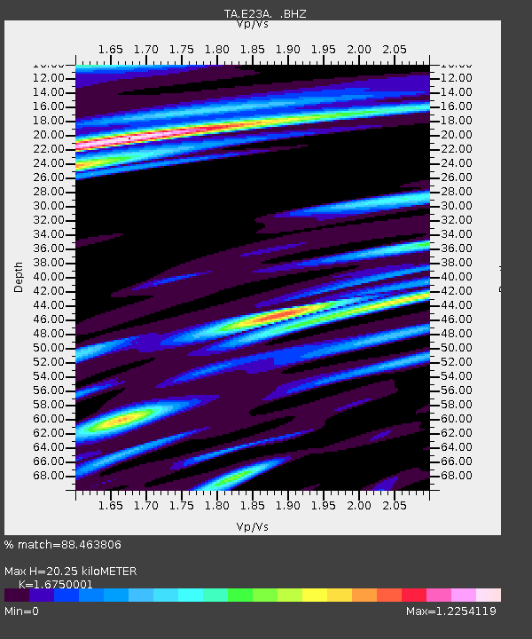
E23A Ismay, MT, USA - Earthquake Result Viewer
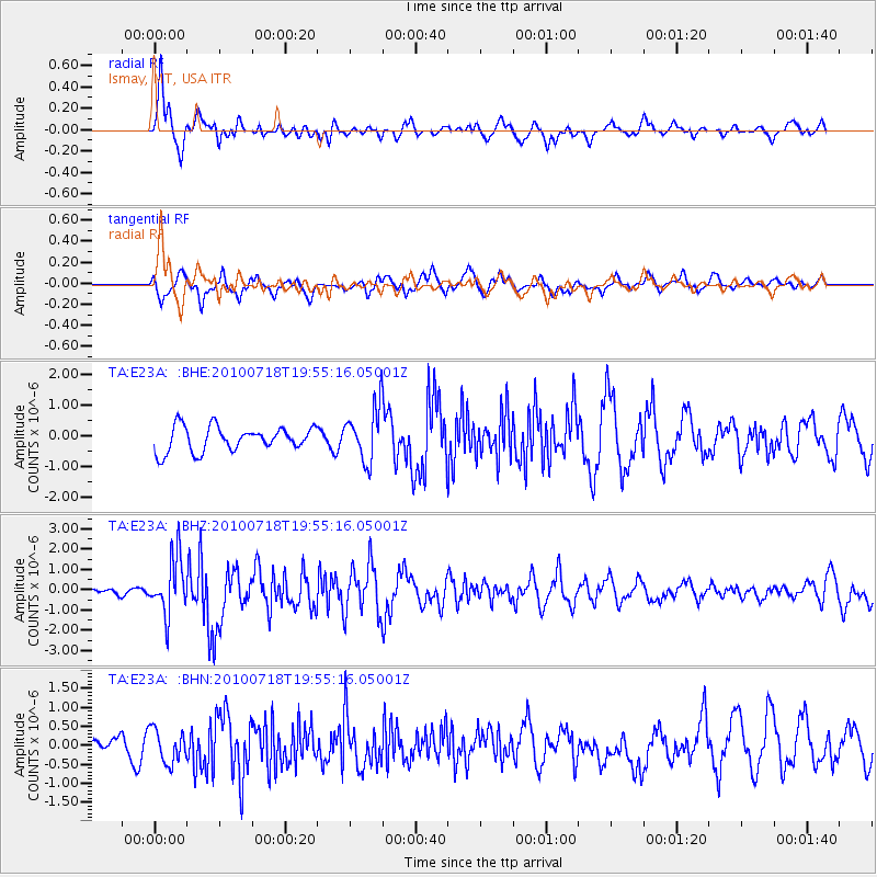
Earthquake location: Fox Islands, Aleutian Islands
Earthquake latitude/longitude: 52.8/-169.7
Earthquake time(UTC): 2010/07/18 (199) 19:48:04 GMT
Earthquake Depth: 10 km
Earthquake Magnitude: 5.6 MB, 5.6 MS, 6.0 MW, 6.0 MW
Earthquake Catalog/Contributor: WHDF/NEIC
Network: TA USArray Transportable Network (new EarthScope stations)
Station: E23A Ismay, MT, USA
Lat/Lon: 46.50 N/105.31 W
Elevation: 750 m
Distance: 40.9 deg
Az: 72.058 deg
Baz: 303.29 deg
Ray Param: 0.074118584
Estimated Moho Depth: 20.25 km
Estimated Crust Vp/Vs: 1.68
Assumed Crust Vp: 6.438 km/s
Estimated Crust Vs: 3.843 km/s
Estimated Crust Poisson's Ratio: 0.22
Radial Match: 88.463806 %
Radial Bump: 400
Transverse Match: 61.468864 %
Transverse Bump: 400
SOD ConfigId: 319893
Insert Time: 2011-01-05 07:17:26.307 +0000
GWidth: 2.5
Max Bumps: 400
Tol: 0.001

Signal To Noise

ChannelStoNSTALTA
TA:E23A: :BHZ:20100718T19:55:16.05001Z11.8978641.3919046E-61.16987756E-7
TA:E23A: :BHN:20100718T19:55:16.05001Z1.91462844.3876045E-72.2916221E-7
TA:E23A: :BHE:20100718T19:55:16.05001Z2.23076348.8667946E-73.97478E-7
Arrivals
Ps2.3 SECOND
PpPs7.8 SECOND
PsPs/PpSs10 SECOND