You are here: Home > Network List > TA - USArray Transportable Network (new EarthScope stations) Stations List
> Station M25A Palm-Egli Farm, Albin, WY, USA > Earthquake Result Viewer
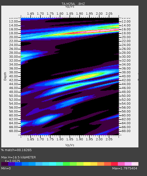
M25A Palm-Egli Farm, Albin, WY, USA - Earthquake Result Viewer
| Earthquake location: |
Fox Islands, Aleutian Islands |
| Earthquake latitude/longitude: |
52.8/-169.7 |
| Earthquake time(UTC): |
2010/07/18 (199) 19:48:04 GMT |
| Earthquake Depth: |
10 km |
| Earthquake Magnitude: |
5.6 MB, 5.6 MS, 6.0 MW, 6.0 MW |
| Earthquake Catalog/Contributor: |
WHDF/NEIC |
|
| Network: |
TA USArray Transportable Network (new EarthScope stations) |
| Station: |
M25A Palm-Egli Farm, Albin, WY, USA |
| Lat/Lon: |
41.43 N/104.06 W |
| Elevation: |
1636 m |
|
| Distance: |
44.6 deg |
| Az: |
77.339 deg |
| Baz: |
308.038 deg |
| Ray Param: |
0.07181588 |
| Estimated Moho Depth: |
16.5 km |
| Estimated Crust Vp/Vs: |
2.00 |
| Assumed Crust Vp: |
6.306 km/s |
| Estimated Crust Vs: |
3.149 km/s |
| Estimated Crust Poisson's Ratio: |
0.33 |
|
| Radial Match: |
88.16265 % |
| Radial Bump: |
370 |
| Transverse Match: |
65.179474 % |
| Transverse Bump: |
400 |
| SOD ConfigId: |
319893 |
| Insert Time: |
2011-01-05 07:17:38.119 +0000 |
| GWidth: |
2.5 |
| Max Bumps: |
400 |
| Tol: |
0.001 |
|

Signal To Noise
| Channel | StoN | STA | LTA |
| TA:M25A: :BHZ:20100718T19:55:45.92501Z | 11.682482 | 1.5446972E-6 | 1.3222338E-7 |
| TA:M25A: :BHN:20100718T19:55:45.92501Z | 1.9787343 | 3.6315302E-7 | 1.8352794E-7 |
| TA:M25A: :BHE:20100718T19:55:45.92501Z | 2.104959 | 5.027437E-7 | 2.3883777E-7 |
| Arrivals |
| Ps | 2.8 SECOND |
| PpPs | 7.4 SECOND |
| PsPs/PpSs | 10 SECOND |


