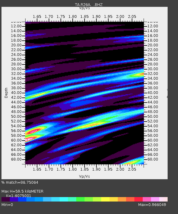
R26A Arlington, CO, USA - Earthquake Result Viewer

Earthquake location: Fox Islands, Aleutian Islands
Earthquake latitude/longitude: 52.8/-169.7
Earthquake time(UTC): 2010/07/18 (199) 19:48:04 GMT
Earthquake Depth: 10 km
Earthquake Magnitude: 5.6 MB, 5.6 MS, 6.0 MW, 6.0 MW
Earthquake Catalog/Contributor: WHDF/NEIC
Network: TA USArray Transportable Network (new EarthScope stations)
Station: R26A Arlington, CO, USA
Lat/Lon: 38.30 N/103.45 W
Elevation: 1304 m
Distance: 46.9 deg
Az: 80.307 deg
Baz: 310.497 deg
Ray Param: 0.0703178
Estimated Moho Depth: 59.5 km
Estimated Crust Vp/Vs: 1.61
Assumed Crust Vp: 6.242 km/s
Estimated Crust Vs: 3.883 km/s
Estimated Crust Poisson's Ratio: 0.18
Radial Match: 86.75064 %
Radial Bump: 389
Transverse Match: 51.966564 %
Transverse Bump: 400
SOD ConfigId: 319893
Insert Time: 2011-01-05 07:18:54.892 +0000
GWidth: 2.5
Max Bumps: 400
Tol: 0.001

Signal To Noise

ChannelStoNSTALTA
TA:R26A: :BHZ:20100718T19:56:04.42501Z8.281959.086298E-71.0971206E-7
TA:R26A: :BHN:20100718T19:56:04.42501Z3.7684514.0939852E-71.0863841E-7
TA:R26A: :BHE:20100718T19:56:04.42501Z5.3169374.5828813E-78.6194014E-8
Arrivals
Ps6.2 SECOND
PpPs23 SECOND
PsPs/PpSs29 SECOND