You are here: Home > Network List > TA - USArray Transportable Network (new EarthScope stations) Stations List
> Station M26A McRoberts Ranch, Bridgeport, NE, USA > Earthquake Result Viewer
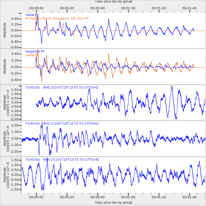
M26A McRoberts Ranch, Bridgeport, NE, USA - Earthquake Result Viewer
*The percent match for this event was below the threshold and hence no stack was calculated.
| Earthquake location: |
Fox Islands, Aleutian Islands |
| Earthquake latitude/longitude: |
52.8/-169.7 |
| Earthquake time(UTC): |
2010/07/18 (199) 19:48:04 GMT |
| Earthquake Depth: |
10 km |
| Earthquake Magnitude: |
5.6 MB, 5.6 MS, 6.0 MW, 6.0 MW |
| Earthquake Catalog/Contributor: |
WHDF/NEIC |
|
| Network: |
TA USArray Transportable Network (new EarthScope stations) |
| Station: |
M26A McRoberts Ranch, Bridgeport, NE, USA |
| Lat/Lon: |
41.47 N/103.14 W |
| Elevation: |
1348 m |
|
| Distance: |
45.1 deg |
| Az: |
76.704 deg |
| Baz: |
308.189 deg |
| Ray Param: |
$rayparam |
*The percent match for this event was below the threshold and hence was not used in the summary stack. |
|
| Radial Match: |
74.19022 % |
| Radial Bump: |
400 |
| Transverse Match: |
48.693295 % |
| Transverse Bump: |
400 |
| SOD ConfigId: |
319893 |
| Insert Time: |
2011-01-05 07:19:32.880 +0000 |
| GWidth: |
2.5 |
| Max Bumps: |
400 |
| Tol: |
0.001 |
|
Signal To Noise
| Channel | StoN | STA | LTA |
| TA:M26A: :BHZ:20100718T19:55:50.075004Z | 6.1324615 | 1.1043131E-6 | 1.8007664E-7 |
| TA:M26A: :BHN:20100718T19:55:50.075004Z | 1.7959206 | 9.496308E-7 | 5.2877107E-7 |
| TA:M26A: :BHE:20100718T19:55:50.075004Z | 2.2227488 | 7.4098824E-7 | 3.3336573E-7 |
| Arrivals |
| Ps | |
| PpPs | |
| PsPs/PpSs | |


