You are here: Home > Network List > TA - USArray Transportable Network (new EarthScope stations) Stations List
> Station T26A Comanche National Grassland Park, Kim, CO, USA > Earthquake Result Viewer
T26A Comanche National Grassland Park, Kim, CO, USA - Earthquake Result Viewer
| Earthquake location: |
Fox Islands, Aleutian Islands |
| Earthquake latitude/longitude: |
52.8/-169.7 |
| Earthquake time(UTC): |
2010/07/18 (199) 19:48:04 GMT |
| Earthquake Depth: |
10 km |
| Earthquake Magnitude: |
5.6 MB, 5.6 MS, 6.0 MW, 6.0 MW |
| Earthquake Catalog/Contributor: |
WHDF/NEIC |
|
| Network: |
TA USArray Transportable Network (new EarthScope stations) |
| Station: |
T26A Comanche National Grassland Park, Kim, CO, USA |
| Lat/Lon: |
37.17 N/103.59 W |
| Elevation: |
1830 m |
|
| Distance: |
47.6 deg |
| Az: |
81.568 deg |
| Baz: |
311.263 deg |
| Ray Param: |
0.069888785 |
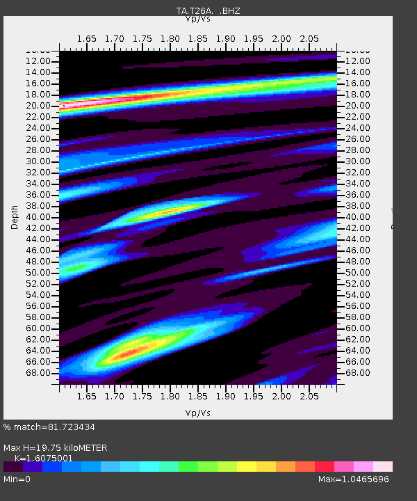
| Estimated Moho Depth: |
19.75 km |
| Estimated Crust Vp/Vs: |
1.61 |
| Assumed Crust Vp: |
6.306 km/s |
| Estimated Crust Vs: |
3.923 km/s |
| Estimated Crust Poisson's Ratio: |
0.18 |
|
| Radial Match: |
81.723434 % |
| Radial Bump: |
400 |
| Transverse Match: |
55.36484 % |
| Transverse Bump: |
400 |
| SOD ConfigId: |
319893 |
| Insert Time: |
2011-01-05 07:20:05.977 +0000 |
| GWidth: |
2.5 |
| Max Bumps: |
400 |
| Tol: |
0.001 |
|
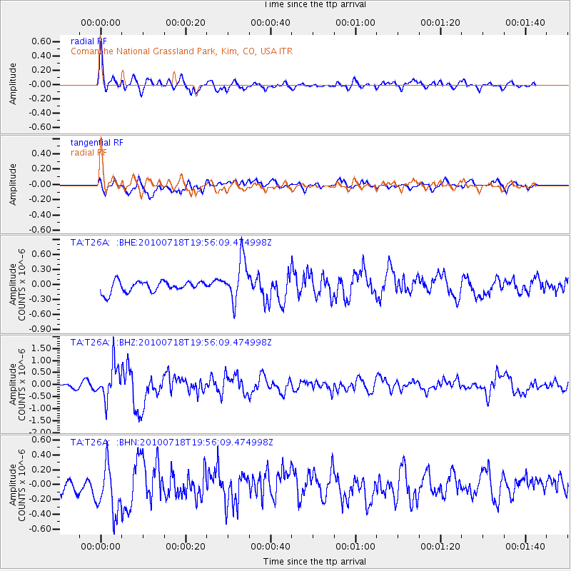
Signal To Noise
| Channel | StoN | STA | LTA |
| TA:T26A: :BHZ:20100718T19:56:09.474998Z | 7.786186 | 7.1485425E-7 | 9.181058E-8 |
| TA:T26A: :BHN:20100718T19:56:09.474998Z | 2.5997472 | 3.31508E-7 | 1.2751548E-7 |
| TA:T26A: :BHE:20100718T19:56:09.474998Z | 3.8969953 | 4.3009445E-7 | 1.10365654E-7 |
| Arrivals |
| Ps | 2.0 SECOND |
| PpPs | 7.7 SECOND |
| PsPs/PpSs | 9.7 SECOND |


