You are here: Home > Network List > UU - University of Utah Regional Network Stations List
> Station FPU Francis Peak, UT, USA > Earthquake Result Viewer
FPU Francis Peak, UT, USA - Earthquake Result Viewer
| Earthquake location: |
Central East Pacific Rise |
| Earthquake latitude/longitude: |
-4.5/-105.8 |
| Earthquake time(UTC): |
2023/09/20 (263) 14:45:59 GMT |
| Earthquake Depth: |
10 km |
| Earthquake Magnitude: |
6.0 Mww |
| Earthquake Catalog/Contributor: |
NEIC PDE/us |
|
| Network: |
UU University of Utah Regional Network |
| Station: |
FPU Francis Peak, UT, USA |
| Lat/Lon: |
41.03 N/111.84 W |
| Elevation: |
2816 m |
|
| Distance: |
45.7 deg |
| Az: |
353.564 deg |
| Baz: |
171.507 deg |
| Ray Param: |
0.071110524 |
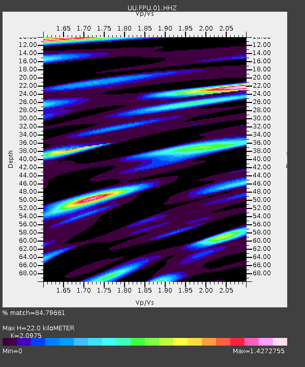
| Estimated Moho Depth: |
22.0 km |
| Estimated Crust Vp/Vs: |
2.10 |
| Assumed Crust Vp: |
6.155 km/s |
| Estimated Crust Vs: |
2.934 km/s |
| Estimated Crust Poisson's Ratio: |
0.35 |
|
| Radial Match: |
84.79661 % |
| Radial Bump: |
399 |
| Transverse Match: |
74.50397 % |
| Transverse Bump: |
400 |
| SOD ConfigId: |
31937991 |
| Insert Time: |
2023-10-04 15:15:29.921 +0000 |
| GWidth: |
2.5 |
| Max Bumps: |
400 |
| Tol: |
0.001 |
|

Signal To Noise
| Channel | StoN | STA | LTA |
| UU:FPU:01:HHZ:20230920T14:53:49.080Z | 2.398629 | 7.0054364E-7 | 2.9206E-7 |
| UU:FPU:01:HHN:20230920T14:53:49.080Z | 2.1930225 | 4.3499335E-7 | 1.9835335E-7 |
| UU:FPU:01:HHE:20230920T14:53:49.080Z | 0.84285975 | 2.1717175E-7 | 2.576606E-7 |
| Arrivals |
| Ps | 4.1 SECOND |
| PpPs | 11 SECOND |
| PsPs/PpSs | 15 SECOND |


