You are here: Home > Network List > TA - USArray Transportable Network (new EarthScope stations) Stations List
> Station P27A Ficken Ranch, Kirk, CO, USA > Earthquake Result Viewer
P27A Ficken Ranch, Kirk, CO, USA - Earthquake Result Viewer
| Earthquake location: |
Fox Islands, Aleutian Islands |
| Earthquake latitude/longitude: |
52.8/-169.7 |
| Earthquake time(UTC): |
2010/07/18 (199) 19:48:04 GMT |
| Earthquake Depth: |
10 km |
| Earthquake Magnitude: |
5.6 MB, 5.6 MS, 6.0 MW, 6.0 MW |
| Earthquake Catalog/Contributor: |
WHDF/NEIC |
|
| Network: |
TA USArray Transportable Network (new EarthScope stations) |
| Station: |
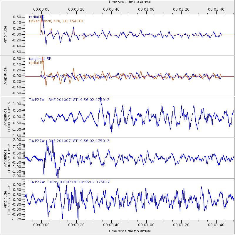
P27A Ficken Ranch, Kirk, CO, USA |
| Lat/Lon: |
39.56 N/102.58 W |
| Elevation: |
1286 m |
|
| Distance: |
46.7 deg |
| Az: |
78.394 deg |
| Baz: |
309.731 deg |
| Ray Param: |
0.07050885 |
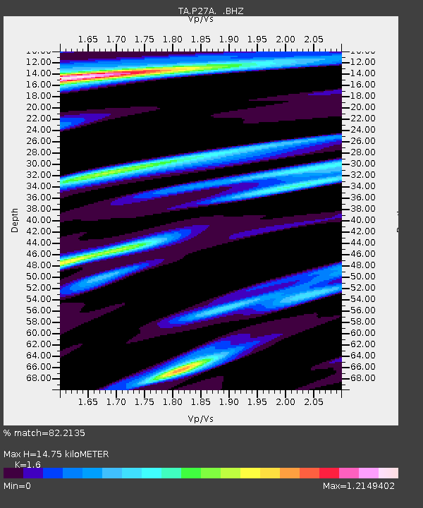
| Estimated Moho Depth: |
14.75 km |
| Estimated Crust Vp/Vs: |
1.60 |
| Assumed Crust Vp: |
6.242 km/s |
| Estimated Crust Vs: |
3.901 km/s |
| Estimated Crust Poisson's Ratio: |
0.18 |
|
| Radial Match: |
82.2135 % |
| Radial Bump: |
376 |
| Transverse Match: |
54.2408 % |
| Transverse Bump: |
400 |
| SOD ConfigId: |
319893 |
| Insert Time: |
2011-01-05 07:20:50.728 +0000 |
| GWidth: |
2.5 |
| Max Bumps: |
400 |
| Tol: |
0.001 |
|
Signal To Noise
| Channel | StoN | STA | LTA |
| TA:P27A: :BHZ:20100718T19:56:02.17501Z | 7.103659 | 8.862916E-7 | 1.247655E-7 |
| TA:P27A: :BHN:20100718T19:56:02.17501Z | 3.0742733 | 4.6472263E-7 | 1.5116504E-7 |
| TA:P27A: :BHE:20100718T19:56:02.17501Z | 3.2040472 | 6.8223613E-7 | 2.1292949E-7 |
| Arrivals |
| Ps | 1.5 SECOND |
| PpPs | 5.8 SECOND |
| PsPs/PpSs | 7.3 SECOND |


