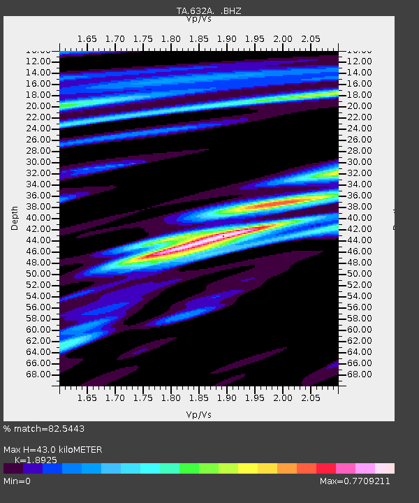
632A Uvalde, TX, USA - Earthquake Result Viewer

Earthquake location: Fox Islands, Aleutian Islands
Earthquake latitude/longitude: 52.8/-169.7
Earthquake time(UTC): 2010/07/18 (199) 19:48:04 GMT
Earthquake Depth: 10 km
Earthquake Magnitude: 5.6 MB, 5.6 MS, 6.0 MW, 6.0 MW
Earthquake Catalog/Contributor: WHDF/NEIC
Network: TA USArray Transportable Network (new EarthScope stations)
Station: 632A Uvalde, TX, USA
Lat/Lon: 29.51 N/99.79 W
Elevation: 420 m
Distance: 55.2 deg
Az: 85.828 deg
Baz: 316.016 deg
Ray Param: 0.064963005
Estimated Moho Depth: 43.0 km
Estimated Crust Vp/Vs: 1.89
Assumed Crust Vp: 6.347 km/s
Estimated Crust Vs: 3.354 km/s
Estimated Crust Poisson's Ratio: 0.31
Radial Match: 82.5443 %
Radial Bump: 400
Transverse Match: 68.24406 %
Transverse Bump: 400
SOD ConfigId: 319893
Insert Time: 2011-01-05 07:22:13.019 +0000
GWidth: 2.5
Max Bumps: 400
Tol: 0.001

Signal To Noise

ChannelStoNSTALTA
TA:632A: :BHZ:20100718T19:57:06.224998Z10.43199357.6369946E-77.320743E-8
TA:632A: :BHN:20100718T19:57:06.224998Z4.6062752.9128518E-76.32366E-8
TA:632A: :BHE:20100718T19:57:06.224998Z3.4552652.2724215E-76.576692E-8
Arrivals
Ps6.3 SECOND
PpPs19 SECOND
PsPs/PpSs25 SECOND