You are here: Home > Network List > TA - USArray Transportable Network (new EarthScope stations) Stations List
> Station POKR Poker Plat Research Range, AK, USA > Earthquake Result Viewer
POKR Poker Plat Research Range, AK, USA - Earthquake Result Viewer
| Earthquake location: |
Northern Molucca Sea |
| Earthquake latitude/longitude: |
2.2/126.7 |
| Earthquake time(UTC): |
2019/01/06 (006) 17:27:20 GMT |
| Earthquake Depth: |
61 km |
| Earthquake Magnitude: |
6.6 mww |
| Earthquake Catalog/Contributor: |
NEIC PDE/us |
|
| Network: |
TA USArray Transportable Network (new EarthScope stations) |
| Station: |
POKR Poker Plat Research Range, AK, USA |
| Lat/Lon: |
65.12 N/147.43 W |
| Elevation: |
501 m |
|
| Distance: |
86.2 deg |
| Az: |
25.017 deg |
| Baz: |
267.151 deg |
| Ray Param: |
0.04409261 |
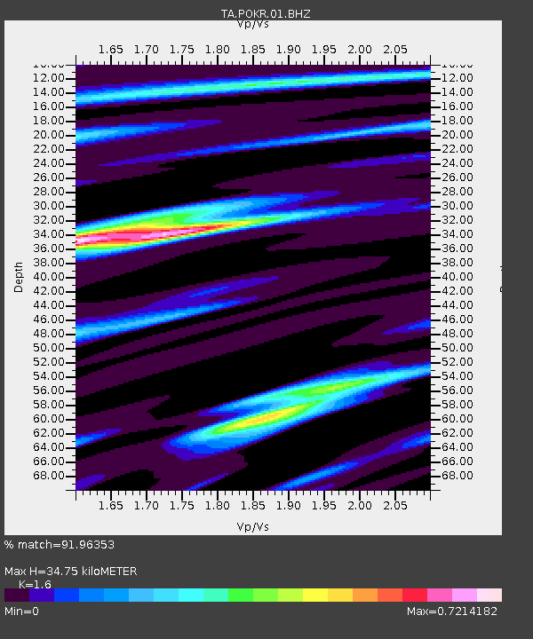
| Estimated Moho Depth: |
34.75 km |
| Estimated Crust Vp/Vs: |
1.60 |
| Assumed Crust Vp: |
6.566 km/s |
| Estimated Crust Vs: |
4.104 km/s |
| Estimated Crust Poisson's Ratio: |
0.18 |
|
| Radial Match: |
91.96353 % |
| Radial Bump: |
376 |
| Transverse Match: |
68.19639 % |
| Transverse Bump: |
400 |
| SOD ConfigId: |
3201911 |
| Insert Time: |
2019-01-20 17:32:33.579 +0000 |
| GWidth: |
2.5 |
| Max Bumps: |
400 |
| Tol: |
0.001 |
|

Signal To Noise
| Channel | StoN | STA | LTA |
| TA:POKR:01:BHZ:20190106T17:39:24.70002Z | 8.004686 | 1.225491E-6 | 1.5309669E-7 |
| TA:POKR:01:BHN:20190106T17:39:24.70002Z | 0.6114666 | 1.3112485E-7 | 2.1444319E-7 |
| TA:POKR:01:BHE:20190106T17:39:24.70002Z | 2.6365888 | 4.2218278E-7 | 1.6012461E-7 |
| Arrivals |
| Ps | 3.3 SECOND |
| PpPs | 13 SECOND |
| PsPs/PpSs | 17 SECOND |


